


ID 627557
Los 67 | Atlas of England and Wales
Schätzwert
$ 60 000 – 90 000
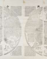
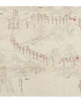
The first national atlas of England and Wales—a monument of early English map-making, hand-colored throughout. Yorkshire native Christopher Saxton, known as the "father of English cartography," was trained as a surveyor and commissioned by Thomas Seckford to map the counties of England and Wales for publication. This finished project earned him the title of Queen's Surveyor. Maps were not a robust part of the English book-making tradition until the Tudor period, particularly the reign of Elizabeth. "It is against this limited background that the assembling of Christopher Saxton's atlas of England and Wales can be seen as such a significant event…this was a larger and more elaborate book than any previously produced in the British Isles" (Worms). It would provide the template for John Speed's 1610 Theatre of Great Britaine.
The engravings bear dates from 1574 to 1579 and the atlas appears in the Stationers' Register under that year; however, it is unclear when the atlas actually appeared on the market. Single maps may have been sold from as early as 1577, when Saxton obtained an exclusive license. Extant copies include a variety of different watermarks with no clear priority. The present copy, with sheets bearing the bunches of grapes mark and the index leaf set in three columns, likely belongs to the circa 1590 issue of the atlas. According to ESTC, this edition was issued without a title page; interestingly, the present copy includes a note by the binder, Rivere, apologizing that he could not locate a title page of this work anywhere. The hand-colored frontispiece of Elizabeth I is here disbound and separately mounted. STC (2nd ed.), 21805.5; Hind, A.M. Engraving in England, I, p.85-95; Skelton TK. See also Laurence Worms, "The London Map Trade to 1640," in The History of Cartography, Volume 3: Cartography in the European Renaissance (2007).
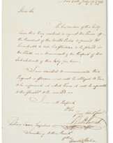
Folio (414 x 290mm). Index leaf in 3 columns and 35 hand-colored maps, all double-page except map of York which is large and folding; state B of hand-colored engraved frontispiece depicting Elizabeth I disbound, trimmed, and separately mounted to cardboard (map of England and Wales defective, missing the righthand quarter and backed with fabric, about 6 maps extended at outer margins, many closely cropped and just shaved at map borders, folding map of York backed with fabric and in several pieces, a few other small closed tears and some mostly marginal staining, a little dustsoiled, index leaf extended at outer margin; lacking heraldry leaf). 19th-century tan morocco gilt by Riviere, with note from Riviere tipped to the flyleaf (worn at extremities, a stain on upper board).
| Künstler: | William Shakespeare (1564 - 1616) |
|---|---|
| Angewandte Technik: | Bleistift |
| Künstler: | William Shakespeare (1564 - 1616) |
|---|---|
| Angewandte Technik: | Bleistift |
| Adresse der Versteigerung |
CHRISTIE'S 8 King Street, St. James's SW1Y 6QT London Vereinigtes Königreich | |
|---|---|---|
| Vorschau |
| |
| Telefon | +44 (0)20 7839 9060 | |
| Aufgeld | see on Website | |
| Nutzungsbedingungen | Nutzungsbedingungen |
Mehr von Creator
Verwandte Begriffe
Jetzt bieten
Per Telefon bieten Gebot

| Losnummer | 67 |
|---|---|
| Auktionshaus | CHRISTIE'S |
| Auktionsdatum | 15.10.2021 |
Ihr Gebot: $ 100
Telefone für die Kommunikation:
+34827387, +232346832
Das ist Ihr maximales Gebot, das an das Auktionshaus übermittelt wird. Wenn das maximale Gebot höher als der Limitpreis des Artikels ist, wird der Versteigerer für Sie bis auf die Höhe des maximalen Gebotes bieten.
Das ist Ihr maximales Vorgebot, das an das Auktionshaus übermittelt wird. Wenn das maximale Vorgebot höher als der minimale Preis des Artikels ist, wird der Auktionator für Sie bis auf die Höhe des maximalen Vorgebotes bieten.
| Losnummer | 67 |
|---|---|
| Auktionshaus | CHRISTIE'S |
| Auktionsdatum | 15.10.2021 |
Gebotsfehler
| Losnummer | 67 |
|---|---|
| Auktionshaus | CHRISTIE'S |
| Auktionsdatum | 15.10.2021 |
Вы уже сделали ставку в € 40 000 и ставка принята аукционным домом. Если вы хотите ее уменьшить, то обратитесь напрямую в администрацию аукционного дома.
Gebotsfehler
| Losnummer | 67 |
|---|---|
| Auktionshaus | CHRISTIE'S |
| Auktionsdatum | 15.10.2021 |
Вы не можете делать ставки в данном АД, т.к. были внесены в черный список.
Jetzt bieten
| Losnummer | 67 |
|---|---|
| Auktionshaus | CHRISTIE'S |
| Auktionsdatum | 15.10.2021 |
Autobid ist vorbereitet
| Losnummer | 67 |
|---|---|
| Auktionshaus | CHRISTIE'S |
| Auktionsdatum | 15.10.2021 |
