ID 381273
Los 65 | Herman Moll (1654-1732).
Schätzwert
£ 5 000 – 8 000
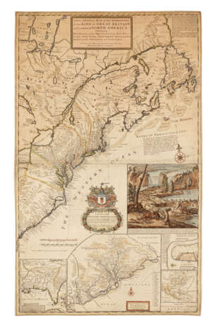
Moll's famous 'Beaver Map' in a very early state; his most celebrated mapping, documenting the ongoing dispute between Great Britain and France over the boundaries separating their colonies in America. The map explains the postal routes throughout the British territories and is generally thought to be the first postal map of the colonies. In sections of text Moll describes the Iroquois along the Appalachian Mountains as '...hearty friends to the English...' and explains the terms outlined in the Treaty of Utrecht. The striking beaver scene inset serves to not only symbolize the industriousness needed to settle in America, but also the lucrative fur trade spreading wealth and opportunity among the colonies. The imprint of this map is a variant on that noted by Tooley as the first state ('Sold by H. Moll, over against Devereux Court without Temple Bar'), and agrees with all other aspects of the first state. Degrees of Latitude 19; Kershaw II, 331; Tooley Mapping of America 55.
Engraved map, on two joined sheets, 1030 x 630mm, general map hand-coloured in outline, elaborate cartouche in lower centre with dedication to the Honourable William Dowglass and inset 'A View of ye Industry of Beavers in Canada' elaborately hand-coloured, four other inset maps or scenes added in lower portion, including 'A Map of the Improved Part of Carolina', 'A Map of the Principal Part of North America', 'A Draught of ye Town and Harbour of Charles-Town', and a map of Louisiana and East Florida (recently expertly mounted on archival paper, the whole lightly browned and at some point folded with creasefolds ironed out, 250mm closed tear in Atlantic Ocean through the explanatory text to the Banks of Newfoundland affecting a few letters but without loss, a few other expertly repaired marginal tears without loss).
| Adresse der Versteigerung |
CHRISTIE'S 8 King Street, St. James's SW1Y 6QT London Vereinigtes Königreich | |
|---|---|---|
| Vorschau |
| |
| Telefon | +44 (0)20 7839 9060 | |
| Aufgeld | see on Website | |
| Nutzungsbedingungen | Nutzungsbedingungen |


