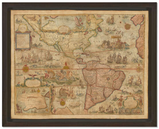
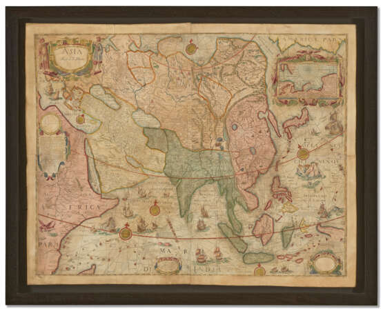
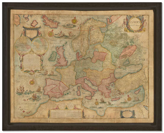
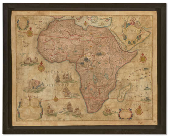
Unrecorded wall maps of the four continents

Los 18
25.04.2022 10:00UTC -05:00
Classic
Startpreis
$ 80 000
AuctioneerCHRISTIE'S
VeranstaltungsortVereinigten Staaten, New York
Archiv
Die Auktion ist abgeschlossen. Es können keine Gebote mehr abgegeben werden.
Archive
ID 743667
Los 18 | Unrecorded wall maps of the four continents
Schätzwert
$ 100 000 – 150 000
BLAEU, Willem (1571-1638). [Four Continents]: Africa: [Nova & Acurata Totius Africae Tabula]; North & South America: [Nova Acurata Totius Americae Tabula]; Asia: [Nova & Acurata Totius Asiae Tabula]]; Europe: [Nova Acurata Totius Europae Tabula]. Bologna, Pietro Todeschi, [1673, or later].Extremely rare, a complete set of Blaeu’s iconic wall maps of the four continents. The pinnacle of Dutch Golden Age decorative cartography, Blaeu’s wall maps occupied a prominent place in Dutch culture as indicators of both affluence and intellectual curiosity, demonstrated by their appearance in several of Johannes Vermeer’s paintings. The leading scholar and scientist, Constantijn Huygens (1596-1687), remarked how he employed his own set of Blaeu’s wall maps of the continents as a tool to enlighten his children: ‘To encourage them even more, I had the four parts of the world by Willem Blaeu mounted in my entrance hall, where they often played, in order to provide them with a fixed image of the world and its division’. Between 1594-1596, Blaeu studied under the eminent Danish astronomer Tycho Brahe, refining his skills in instrument- and globe-making. Upon his return to Amsterdam, he established the Officina Blaviana, selling maps, globes, scientific instruments, and editing and publishing the works of intellectuals such as Descartes and Grotius. He was extremely successful in a very competitive cartographic market, and to establish his pre-eminence engaged the important cartographer Hessel Gerritsz (1580-1632), and the skilled engraver Joshua van de Ende (b.1583/4) to produce a set of the most accurate wall maps of the continents possible. The first edition was produced in 1608, and a further issue was published in 1612. Eventually the plates found their way to Hendrik Hondius, who published an edition in 1624, and finally passing to Nicholas Visscher, who employed them in 1655-7. All editions of Blaeu wall maps are extreme rarities, with only one incomplete set of the 1608 original surviving (missing the map of Africa), having been discovered in Switzerland in 1979. The popularity of Blaeu’s maps was such that they were pirated in Italy and France. The Venetian printer Stefano Mozzi Scolari (1598-1650) produced a version in about 1646, and it is from this publication that the present lot is derived, engraved by Pietro Todeschi in Bologna in the early 1670s and published in 1673, probably by Giuseppe Longhi (Schilder). Sets of these are rare in themselves: we have only been able to find the following institutional examples: Library of Congress (2 examples); Harry Ransome Center, UT, Austin; Royal Geographical Society, London; Luneburg Museum, Germany; Societa Geografica Italiana, Rome; Koninklijke Hollandsche Lloyd, Amsterdam (untraced); Biblioteca Apostolica Vaticana. AMERICA: ‘One of the most influential maps of America ever made’ (Burden I, 156). Blaeu and Gerritsz acquired advanced sources, and while the largely unexplored Pacific coast of North America extends to too far to the west, the overall proportions of the continent are well assured for the time. Over to the Atlantic, Nova Scotia has taken shape, based on the voyages of Samuel de Champlain and Pierre Gua de Monts from 1604. New England is less defined indicating that intelligence of the English reconnaissance of the region in 1602 had not yet reached Amsterdam, while the depiction of the southeast is quite advanced. The width of South America is overly attenuated, consistent with all maps of a period in which the determination of longitude was an inexact science. The Todeschi edition can be differentiated from other editions by a few changes in toponyms, and as Burden notes: ‘One notable deviation from all those before is an attempt to correlate the map with the California as an island theory. This was achieved by creating an island out of Baja California’ (Burden II, 433).On the inset map of the Great Southern Continent ‘is the name Stretto Lamairo. The drawing of a coastline with the name Ant. van Diemens lant refers to the discovery of Tasmania by Abel Jansz Tasman in 1642. The addition detecta 1667 near Boach Provincia (the name Beach was more usual for the northern most tip of the Southern Continent) may be a mistake of the engraver: in 1627 Pieter Nuijts sailed along the south coast of present-day Australia’ (Schilder, p.197). The cartouche in the lower right depicts the discovers of the New World, Christopher Columbus and Amerigo Vespucci, below which are four roundels containing the portraits of the four circumnavigators, Ferdinand Magellan, Sir Francis Drake, Sir Thomas Cavendish and Olivier Van Noort. AFRICA: The map of Africa depicts the European conception of the continent at the dawn of the seventeenth-century, an especially interesting juncture when the coastlines were well-explored, but its heart remained an enigma. Blaeu was influenced by Giacomo Gastaldi’s large map of 1564, which was copied in Antwerp by Cornelis De Jode, as well as Abraham Ortelius’ maps of 1595. He also considered the maps present in Filippo Pigafetta’s book on the Congo, based on the explorations of Duarte Lopes (1591) and the map included in the second edition of Giovanni Battista Ramusio’s Navigatione et Viaggi (1550), in addition to Portuguese sources included in Jan Huygens van Linschotens Itinerario (1596). In west Africa, Blaeu depicted territorial divisions similar to Gastaldi and Ortelius, labelling both Barbaria and Libya Interior. The Niger and Senegal Rivers combine to flow into the Atlantic as one great system, with an apocryphal Lake Niger being the source for the latter. The great entrepot of Tombotu (Timbukto) is shown and the Gold Coast is based a map by Luis de Texiera, which found its way to Amsterdam in 1602. Central Africa is derived from Ortelius and Pigafetta, and South Africa is updated by the inclusion of Dutch nomenclature, such as Mossel baij, from the reconnaissance of Cornelis De Houtman, 1595-97. The southern interior is based on Portuguese sources, with the frontier fort Cast[ellum] Portugal labelled on the map. The source of the heart of the continent, entirely unknown, is derived from the ancient maps of Ptolemy, which show both the sources of Nile and Zambezi Rivers as being lakes on other side of the mythical Mountains of the Moon. Abyssinia is taken from Ortelius’s imaginative maps of the legendary Christian kingdom of Prester John. The map is lavishly decorated, with four cartouches, one playfully adorned with a monkey. Sea monsters inhabit the seas and elephants, rhinoceroses, camels and ostriches roam the continent.ASIA: Blaeu’s map of Asia captures the continent right at the critical period when the newly formed Dutch East India Company (the VOC) was challenging Portuguese hegemony in the Far East. Willem Blaeu, who would later be appointed the official hydrographer to the VOC, had access to the unrivalled map collection of Petrus Plancius, who, in addition to Dutch sources, also acquired manuscripts from Bartholemmeo de Lasso in Lisbon by way of espionage, in 1592-94. Blaeu first employed these sources on his 1605 folio map of Asia. Ceylon and the Maldives are derived from Linschoten, and Java and Bali show advanced information from Willem Lodewijksz’s map during his recent voyage with De Houtman. The enigmatic nature of eastern Borneo and the Celebes is betrayed by their delineation with dotted lines and the spice island of Banda features Dutch nomenclature. New Guinea shows the most advanced depiction of the period, and Honshu, Japan, is derived from Ortelius’ 1595 map. The mythical Strait of Anian, the gateway to the Northwest Passage, appears in the northeast. In homage to the imagination, China features Cambalu, a capital city with an immense 28 mile perimeter, governed by the Great Cham. In the Arctic, the recent attempts by Willem Barents to navigate a Northeast Passage are indicated by the appearance of the island of Novaya Zemlya. The Aral Sea is notably absent, and the Caspian maintains the egg-shape prevalent until the 1730s. EUROPE: Blaeu’s map of Europe is especially magnificent in design, and its advanced geography is indicative of Blaeu’s sourcing of manuscript pilot maps drafted by the North Holland School of Hydrographers. The large cartouche resting in the Atlantic features Gerritsz’s brilliantly executed double-hemispheric map, surmounted by the Arms of the City of Amsterdam, a reference to Blaeu’s official privileges. References: Betz, The Mapping of Africa, 54 (1608) and 117 (1673); Burden, The Mapping of North America I, 156 (1608) and II, 433 (1673); Schilder, Monumenta Cartographica Neerlandica, Vol. V, pp.192-197; Suarez, Early Mapping of Southeast Asia pp.223-227. Set of four engraved wall maps (each 815 x 1065mm), printed on four joined sheets each, expertly colored by a modern hand (without surrounding side-panels, a few tiny marginal nicks and tears, fairly uniform light browning and light staining, minor points of surface loss, restoration visible at margins, joins and a few closed tears, Asia map a bit wrinkled). Individually float-mounted and framed.
Adresse der Versteigerung CHRISTIE'S
20 Rockefeller Plaza
10020 New York
Vereinigten Staaten
Vorschau
11.04.2022 – 25.04.2022
Telefon +1 212 636 2000
Fax +1 212 636 4930
E-Mail
NutzungsbedingungenNutzungsbedingungen
Versand Postdienst
Kurierdienst
Selbstabholung
Zahlungsarten Banküberweisung
GeschäftszeitenGeschäftszeiten
Mo 09:30 – 17:00   
Di 09:30 – 17:00   
Mi 09:30 – 17:00   
Do 09:30 – 17:00   
Fr 09:30 – 17:00   
Sa geschlossen
So geschlossen

Verwandte Begriffe