ID 411439
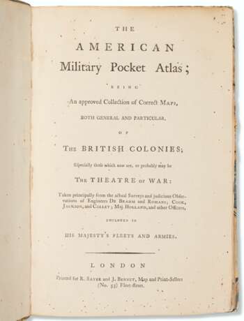
Lot 32 | "Holster Atlas" of the Revolution
Estimate value
$ 8 000 – 12 000
First edition of the so-called "holster atlas" designed “to suit the pockets of officers of all ranks” for use in the field during the American Revolution. The maps are those “that the British high command regarded as providing essential topographical information in the most convenient form” (Schwartz & Ehrenberg). Howes A-208; Sabin 1147; Schwartz & Ehrenberg, p 190; Streeter sale 73.
Octavo (225 x 148mm). (Few spots to title.) 6 folding engraved maps printed on heavy paper, hand-colored in outline, comprising: 1. DUNN, Samuel. North America as Divided amongst the European Powers. 1774. 2. DUNN. A Compleat Map of the West Indies. 1774. 3. A General Map of the Northern British Colonies in America. Which comprehends the Province of Quebec, The Government of Newfoundland, Nova-Scotia, New-England and New-York. 1776. 4. A General Map of the Middle British Colonies, in America. Containing Virginia, Maryland, the Delaware Counties, Pennsylvania and New Jersey. 1776. 5. ROMANS, Bernard. A General Map of the Southern British Colonies, in America. Comprehending North and South Carolina, Georgia, East and West Florida. 1776. 6. BRASSIER, William. A Survey of Lake Champlain, including Lake George, Crown Point and St. John. 1776. Contemporary calf-backed marbled boards, red morocco spine label, spine with raised bands (light rubbing to binding, corners showing).
| Address of auction |
CHRISTIE'S 8 King Street, St. James's SW1Y 6QT London United Kingdom | |
|---|---|---|
| Preview |
| |
| Phone | +44 (0)20 7839 9060 | |
| Buyer Premium | see on Website | |
| Conditions of purchase | Conditions of purchase |


