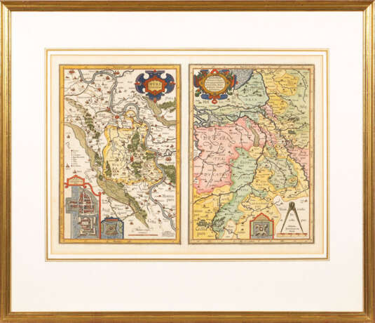
Landkarte von Moers - Gerhard Mercator

Lot 418
20.06.2019 15:00UTC +01:00
Classic
Sold
€ 180
AuctioneerKunst-Auktionshaus Wendl
Event locationGermany, Rudolstadt
Buyer Premium21.42%
Archive
The auction is completed. No bids can be placed anymore.
Archive
ID 201749
Lot 418 | Landkarte von Moers - Gerhard Mercator
Landkarte von Moers - Gerhard Mercator / Jodocus Hondius. Kolorierter Kupferstich, Platte je 36 x 24,5 cm, verglast und gerahmt 63 x 73 cm. 2 nebeneinanderliegende Landkarten auf einem Blatt: 1x Grafschaft Moers mit Stadtansicht von Moers aus der Vogelperspektive und 1x Grafschaft Moers innerhalb umliegender Regionen; aus dem Mercator-Hondius-Atlas (nach 1606). Bugfalte. n Gerhard Mercator (1512 - 1594) galt in Gelehrtenkreisen seiner Zeit bereits als bedeutendster Kartograf, der das Konzept "Atlas" entwickelte. Mit der von ihm entworfenen "Mercator-Projektion" in Weltkarten erlangte er Weltruhm, denn die eingezeichneten Linien waren für die Navigation in See- und Luftfahrt unverzichtbar. n Jodocus Hondius (1563 - 1612) erweiterte Mercators Weltatlas um ca. 40 Platten nach dessen Tod. ABB.B 377
Address of auction Kunst-Auktionshaus Wendl
August-Bebel-Straße 4
07407 Rudolstadt
Germany
Preview
15.06.2019 – 22.06.2019
Phone +49 3672 424350
Fax +49 3672 412296
Email
Buyer Premium 21.42
Conditions of purchaseConditions of purchase
Business hoursBusiness hours
Mo 09:00 – 12:30    14:00 – 17:00
Tu 09:00 – 12:30    14:00 – 17:00
We 09:00 – 12:30    14:00 – 17:00
Th 09:00 – 12:30    14:00 – 17:00
Fr 09:00 – 12:30    14:00 – 17:00
Sa closed
Su closed

Related terms

?>