ID 411433
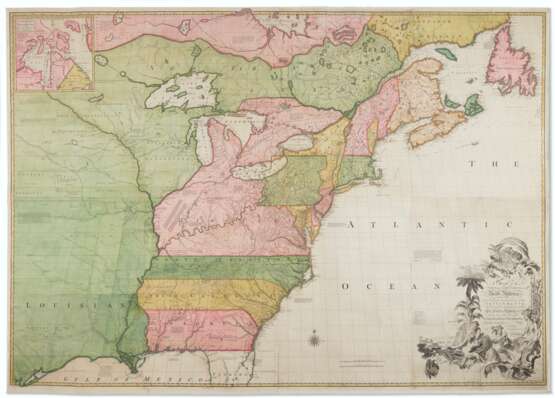
Lot 26 | “The most important map in American history”
Estimate value
$ 70 000 – 100 000
Over six-feet long, the map widely regarded as the most important in American history. First edition. Prepared on the eve of the French and Indian War, Mitchell's is the second large-format map of North America printed by the British (the first being Henry Popple’s map of 1733), and it includes the most up-to-date information on the region. Over the following century, it would play a significant role in the resolution of every significant dispute involving the northern border of the then-British Colonies and in the definition of the borders of the new United States of America.
John Mitchell was born in Virginia and educated in medicine in Edinburgh, Scotland. He returned to Virginia and practiced as a physician before emigrating back to England in 1746, where he was introduced to the president of the Board of Trade and Plantations, the Earl of Halifax. Matthew Edney suggests that it was most likely Halifax who approached Mitchell to serve as an expert on colonial affairs and later commissioned him to draw a map of America to define English territorial rights. Mitchell’s first attempt resulted in a manuscript map finished in 1750, but this prototype proved insufficient. Halifax issued a special directive ordering every colonial governor on the North American mainland to send detailed accounts and maps of their colonies and boundaries, and also gave Mitchell access to the Board’s archives, including maps by Joshua Fry and Peter Jefferson, Christopher Gist, George Washington, and John Barnwell. The map was ultimately used by Halifax to push his aggressive colonial policies in North America, and Mitchell’s work, although impeccably sourced, was an unapologetic statement of British claims in the continent—to the extent that the chancellor, the Earl of Hardwicke, was worried that its publication would lead to public outcry if the government compromised with the French.
Mitchell’s work was immediately popular and spawned a host of imitations. The map’s credentials, linked to both Halifax and the Board of Trade, gave it an authority beyond contemporary productions: even Henry Popple’s landmark map of America was only produced by the permission of the Board of Trade, rather than with its cooperation. It represented a landmark in the history of the cartography of America as the most efficiently sourced and drawn map of the period and in its use of cartography in government policy. This is an example of Tooley’s first edition, second issue (54b), of five; and Pritchard & Taliaferro’s 3rd state, of seven, with the town of Leicester named twice in Massachusetts.
Large engraved wall map fully hand-colored in eight sections, overall 1360 by 1950mm, modern linen mount. (Few minor spots, some rolling creases visible on right side, chiefly in Atlantic Ocean. Two sections lightly toned.)
| Address of auction |
CHRISTIE'S 8 King Street, St. James's SW1Y 6QT London United Kingdom | |
|---|---|---|
| Preview |
| |
| Phone | +44 (0)20 7839 9060 | |
| Buyer Premium | see on Website | |
| Conditions of purchase | Conditions of purchase |


