


ID 1073294
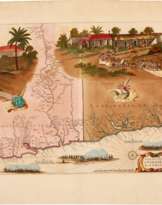
Los 16 | Joan Blaeu | Novum ac magnum theatrum urbium Belgicae regiae. Amsterdam, 1649
Schätzwert
£ 30 000 – 50 000
Novum ac magnum theatrum urbium Belgicae regiae, ad praesentis temporis faciem expressum a Joanne Blaeu. Amsterdam: Joan Blaeu, [27 September] 1649
Folio (570 x 355 mm.), printed title withing engraved armorial frame, 147 engraved plates, comprising 8 in the text (one double-page), 4 full-page, one folding map, 134 double-page plates (56 with four images, one with three, 12 with two, and 63 with one), ALL FINELY COLOURED BY A CONTEMPORARY HAND, contemporary Dutch vellum gilt, floral roll frame, leafy floral cornerpieces and large central lozenge, spine gilt in compartments with central palmette, blue morocco label, yapp edges, occasional browning, slight wear to binding
A beautifully hand-coloured copy of Blaeu’s atlas showing the region of the Low Countries—comprising territory that is now Belgium—left under the control of the Spanish crown after the Peace of Munster ended the Dutch War of Independence (1568-1648).
A companion volume featuring the towns of the new Dutch Republic (“Urbium Belgicae Foederatae”) was issued simultaneously with this volume, but the two atlases are often found separately.
In his bibliography of the great Dutch atlases, Koeman says that “of all the Blaeu atlases, the townbooks of the Netherlands are held in the highest esteem in the Netherlands,” and van der Krogt says that the maps “show the proud and industrious cities of the North in their full splendour.” Our third edition in Latin, published at the same time as the first edition in Dutch, is especially valued because its maps reflect changes in the political situation that occurred after the publication of the first and second editions earlier in the year; and it contains four additional engravings included here for the first time. These show views and plans of Thérouanne (Tarvenna) and a plan of Aire (Aria), and the detailed maps of the towns of Gulich and Lingen (Linga). The mostly double-page engravings comprise topographical maps, city plans, and views of the towns, with all three sometimes combined, via vignettes and insets, into the same engraving.
Joan [or Johannes] Blaeu (1596-1673) and his father Willem (1571-1638) were major figures in the golden age of the Dutch/Netherlandish School of cartography in the 16th and 17th
centuries. Joan served as the official cartographer of the Dutch East India Company, then the leading player in global trade.
| Künstler: | Jan Willemsz. Blaeu (1596 - 1673) |
|---|---|
| Kategorie des Auktionshauses: | Drucke, Graphik, Bücher |
| Künstler: | Jan Willemsz. Blaeu (1596 - 1673) |
|---|---|
| Kategorie des Auktionshauses: | Drucke, Graphik, Bücher |
| Adresse der Versteigerung |
Sotheby´s 34-35 New Bond Street W1A 2AA London Vereinigtes Königreich | |
|---|---|---|
| Vorschau |
| |
| Telefon | +44 (0) 20 7293 5000 | |
| Telefon | +1 212 606 7000 | |
| Nutzungsbedingungen | Nutzungsbedingungen |
![[Atlas Major], Dutch text, 1648-1664, 9 volumes](/assets/image/picture_3109202/d41e8/0grfsdppvzk3dpml6rtse7s-fdfiawp2leakzr3v3nh63nm87v5qrm6yf-iysvtj1694249789jpg__fix_162_205.jpeg)
Verwandte Begriffe
Jetzt bieten
Per Telefon bieten Gebot

| Losnummer | 16 |
|---|---|
| Auktionshaus | Sotheby´s |
| Auktionsdatum | 28.11.2023 |
Ihr Gebot: £ 30 000
Telefone für die Kommunikation:
+34827387, +232346832
Das ist Ihr maximales Gebot, das an das Auktionshaus übermittelt wird. Wenn das maximale Gebot höher als der Limitpreis des Artikels ist, wird der Versteigerer für Sie bis auf die Höhe des maximalen Gebotes bieten.
Das ist Ihr maximales Vorgebot, das an das Auktionshaus übermittelt wird. Wenn das maximale Vorgebot höher als der minimale Preis des Artikels ist, wird der Auktionator für Sie bis auf die Höhe des maximalen Vorgebotes bieten.
| Losnummer | 16 |
|---|---|
| Auktionshaus | Sotheby´s |
| Auktionsdatum | 28.11.2023 |
Gebotsfehler
| Losnummer | 16 |
|---|---|
| Auktionshaus | Sotheby´s |
| Auktionsdatum | 28.11.2023 |
Вы уже сделали ставку в € 40 000 и ставка принята аукционным домом. Если вы хотите ее уменьшить, то обратитесь напрямую в администрацию аукционного дома.
Gebotsfehler
| Losnummer | 16 |
|---|---|
| Auktionshaus | Sotheby´s |
| Auktionsdatum | 28.11.2023 |
Вы не можете делать ставки в данном АД, т.к. были внесены в черный список.
Jetzt bieten
| Losnummer | 16 |
|---|---|
| Auktionshaus | Sotheby´s |
| Auktionsdatum | 28.11.2023 |
Autobid ist vorbereitet
| Losnummer | 16 |
|---|---|
| Auktionshaus | Sotheby´s |
| Auktionsdatum | 28.11.2023 |
