ID 1105615
Los 98 | MOLL, Herman (c.1654-1732)
Schätzwert
£ 6 000 – 8 000
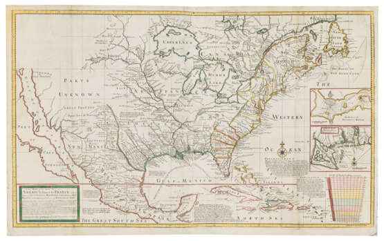
A New Map of the North Parts of America claimed by France under ye names of Louisiana, Mississipi, Canada and New France with the Adjoyning Territories of England and Spain. Dublin: George Grierson, [c.1735].
Very rare Irish edition of Herman Moll's heavily-politicised map of North America, presenting strong counterclaims against the cartography of Delisle. In 1718, Guillaume Delisle published his map Carte de Louisiane et du Cours du Mississipi [sic], which has been described by Schwartz and Ehrenberg as a ‘chauvinistic pictorial argument supporting French authority [and] showed the British colonies surrounding the French possessions in the west, and it claimed the Carolinas for France’ (p.140). By way of reaction, Moll produced this map, actually based on Delisle’s, but with the addition of 'original draughts of Mr Blackmore, the Ingenious Mr Berisford now Residing in Carolina, Cap.t Nairn and others never before Publish'd'. Moll makes a clear written statement of the English claim to the Carolinas while the title cartouche complains of French ‘Incroachments’. Moll marks the territory of the 'Charakeys and Iroquois, by much the most powerfull of all ye Neighbouring Indian Nations, the old Friends and Allies of the English', whom he describes as the 'Bulwark and Security' between the British plantations and the French.
George Grierson (1680-1753) was a leading Dublin publisher, 'Printer to the King in Ireland' from 1732, who copied several of Moll's atlases. However, Grierson respected the copyright laws of the time, and there are enough differences, both large – the inset view of ‘The Indian Fort Sasquesahanok’ has been erased – and small, to indicate this is a new plate. This map appeared in Grierson’s edition of Moll's The World Described, of which there one known institutional example (R.G.S., London). The present lot is the second of two known editions of Grierson's map, with the dedication to Ambrose Philips removed. We have only been able to trace one copy of the first state at auction (RBH), and none of this edition. McLaughlin, The Mapping of California as an Island 197 (‘Shows southern part of California and Gulf of California, which widens at north’); Phillips, America, p. 567; Cumming, The Southeast in Early Maps, pp. 43-44.
Engraved map on two joined sheets within yellow-coloured border of latitude and longitude scales, contemporary hand colouring of borders to reflect the contested boundaries of North America between France, England, and Spain at the time, scale projection to lower right with colour wash, Tropic of Cancer in red, compass rose, title cartouche with decorative frame to lower-left and Grierson’s imprint just to its right, two inset maps of ‘The Harbour of Annapolis Royal’ and ‘A Map of ye Mouth of Mississipi [sic] and Mobile Rivers’ within frames to right, blank area to top left where former inset of ‘The Indian Fort Sasquesahanok’ has been erased, 610 x 1010mm (plate mark), 633 x 1030mm (sheet).
| Adresse der Versteigerung |
CHRISTIE'S 8 King Street, St. James's SW1Y 6QT London Vereinigtes Königreich | ||||
|---|---|---|---|---|---|
| Vorschau |
| ||||
| Telefon | +44 (0)20 7839 9060 | ||||
| Aufgeld | see on Website | ||||
| Nutzungsbedingungen | Nutzungsbedingungen |


