ID 1032975
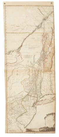
Los 316 | The Provinces of New York and New Jersey
Schätzwert
$ 2 000 – 3 000
Large map of the mid-Atlantic colonies based on the surveys of Samuel Holland and Governor Thomas Pownall. This map, published in Thomas Jefferys' great American Atlas of 1775, is based on that of 1768. It covers the region from Lac St. Pierre in Quebec all the way south to Cape James in Maryland.
Hand-colored engraved map comprising two engraved and joined sheets, engraved pictorial cartouche bottom right, together approximately 1360 x 540mm (53.5 x 21 inches) sheet size (top edge hinged to later paper panel with grommets, toned and with some pale dampstain, coloring faded, small stain in upper left, right edge slightly trimmed outside of neat line, folds reinforced on verso).
| Künstler: | Samuel Holland (1728 - 1801) |
|---|---|
| Kategorie des Auktionshauses: | Karten und Atlanten |
| Künstler: | Samuel Holland (1728 - 1801) |
|---|---|
| Kategorie des Auktionshauses: | Karten und Atlanten |
| Adresse der Versteigerung |
CHRISTIE'S 20 Rockefeller Plaza 10020 New York Vereinigten Staaten | ||||||||||||||
|---|---|---|---|---|---|---|---|---|---|---|---|---|---|---|---|
| Vorschau |
| ||||||||||||||
| Telefon | +1 212 636 2000 | ||||||||||||||
| Fax | +1 212 636 4930 | ||||||||||||||
| Nutzungsbedingungen | Nutzungsbedingungen | ||||||||||||||
| Versand |
Postdienst Kurierdienst Selbstabholung | ||||||||||||||
| Zahlungsarten |
Banküberweisung | ||||||||||||||
| Geschäftszeiten | Geschäftszeiten
|


