ID 1073322
Los 33 | William Faden and others | Composite atlas. London, 1743-1788
Schätzwert
£ 10 000 – 15 000
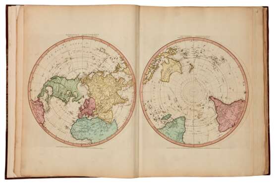
Composite atlas. London, [maps dated, 1743-88]
Folio (558 x 418mm.), contemporary manuscript table of contents, 47 maps and charts by Faden, Sayer and Jefferys, and others (26 folding, 20 double-page), 41 coloured by hand contemporary marbled paper boards, raised bands, spine gilt, a few folds at tears, some faint offsetting, boards rubbed, binding expertly rebacked and re-cornered to style using eighteenth-century diced russia
A VALUABLE COMPOSITE ATLAS COMPOSED OF LARGE-SCALE MAPS BY THE LEADING CARTOGRAPHERS AND ENGRAVERS OF THE PERIOD. Taken together, these maps provide a fascinating glimpse of the world as known to Europeans in the mid- to late-eighteenth century, and insight into the areas deemed most significant for their commercial, political, or military value to the great European powers.
The atlas includes the rare “Chart of the West Indies” published by Speer in 1774 (found here in its second state, with “Arts and Commerce” gold medal added). A hydrographer and a pilot for the Royal Navy, Speer (fl. 1765-1792) had travelled extensively around the West Indies and Caribbean. His chart provides a critical view of the Caribbean, West Indies, and the colonized south-eastern region of North America just before the revolution. As Nebenzahl notes in his Atlas of the American Revolution, “The rich island colonies were of great significance to the British, French, Spanish, Dutch, and even the Danes” during that conflict. As a Navy pilot, Speer was extremely sensitive to tensions in the region, and
our Chart is coloured as set forth in his “Explanation and directions for colouring” to delineate the areas under the rule of these various nations, with a further listing of neutral countries. There is also much useful information on sea hazards, ocean depth, and trade winds.
William Faden (1750-1836) began his career as apprentice to a Fleet Street engraver in 1764, and in 1773 went into partnership with the heirs of engraver Thomas Jefferys. By 1776 he had gone out on his own, and ODNB says that “in the years of the American wars Faden came to prominence with maps and atlases of considerable historical note” and was
seen by contemporaries as a “’very accurate, industrious young man’”. In 1783, he was named Geographer in Ordinary to the king, and “developed the most competent cartographic service of the period”, with his maps “reputed the finest being engraved anywhere in the world”.
Thomas Jefferys (ca. 1710-71) is especially notable for his maps of North America; in 1768 he issued A General Topography of North America with Robert Sayer (1725-1794). Sayer had primarily focused his engraving business on English topographical and county maps before acquiring Jefferys’ plates, stock, and drawings when the latter went bankrupt in 1766, an event that gave Sayer access to lucrative maps of North America. ODNB observes that “Sayer’s success was based on commercial rather than creative skills. He achieved a leading position in the print, map, and chart trades by benefiting from common production facilities and distribution channels and exploiting the expanding markets in all three fields”.
Our atlas has seven sets of two maps that can be combined to form one larger map for a more complete view of Africa, the Americas, Asia, the Black Sea region, Europe, or the Mediterranean. There are also ocean charts, maps of India, a Mercator-style world map that shows the route of Cook’s voyages, and a map, based on Cook’s survey, showing the far northwest coast of North America and the northeast coast of Asia.
| Künstler: | Robert Sayer (1725 - 1794) Thomas Jefferys (1719 - 1771) William Faden (1749 - 1836) |
|---|---|
| Kategorie des Auktionshauses: | Drucke, Graphik, Bücher |
| Künstler: | Robert Sayer (1725 - 1794) Thomas Jefferys (1719 - 1771) William Faden (1749 - 1836) |
|---|---|
| Kategorie des Auktionshauses: | Drucke, Graphik, Bücher |
| Adresse der Versteigerung |
Sotheby´s 34-35 New Bond Street W1A 2AA London Vereinigtes Königreich | |
|---|---|---|
| Vorschau |
| |
| Telefon | +44 (0) 20 7293 5000 | |
| Telefon | +1 212 606 7000 | |
| Nutzungsbedingungen | Nutzungsbedingungen |


