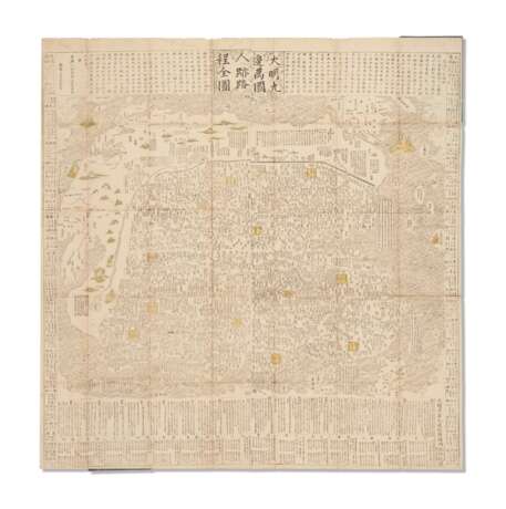
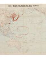
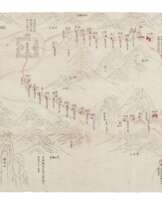
Complete Map of Human Traces and Travel Routes within the Myriad States of the Nine Borders of the Great Ming
15.10.2021 00:00UTC +00:00
Classic
Sold
40000USD $ 40 000
| Auctioneer | CHRISTIE'S |
|---|---|
| Event location | United Kingdom, London |
| Buyer Premium | see on Website% |
Archive
The auction is completed. No bids can be placed anymore.

ID 627561
Lot 71 | Complete Map of Human Traces and Travel Routes within the Myriad States of the Nine Borders of the Great Ming
Estimate value
$ 40 000 – 60 000
Large Japanese rendering of Wang Junfu's important map of Ming China, borders of which are established by the Great Wall of China in the north, the Yellow River to the west, and by oceans to the east and south. The map was published by a Japanese bookseller in Kyoto, Umemura Yahaku, based on the map Tianxia Jiubian Wanguo Renji Lucheng Quantu [Complete Map of Human Traces and Travel Routes within the Myriad States of the Nine Borders under the Heaven]. This was published by Wang Junfu (fl. c. 1650-1680), probably a Ming loyalist from Suzhou, in the second year of Kangxi’s reign (1663), within a year of the fall of the Southern Ming regime (1644-1662). Wang Junfu’s map was developed from Tianxia Jiubian Fenye Renji Lucheng Quantu [Complete Map of Human Traces and Travel Routes within the Allotted Fields of the Nine Borders under Heaven] produced by Cao Junyi from Nanjing in 1644, shortly after the collapse of the Ming dynasty. The models of Cao Junyi’s map include Qiankun Wanguo Quantu Gujin Renwu Shiji [Complete Map of the Myriad States within the Cosmos, noted with Events in the Past and Present] made by Liang Zhou in the late-Ming period, 1593, and Jiuzhou Fenye Yutu Gujin Renwu Shiji [Map of Allotted Fields of the Nine Regions (of China), noted with Events in the Past and Present] published by Ji Mingtai in 1583. This cartographic lineage, culminating in the version of the present lot, represents the Chinese understanding of the world in the late-Ming period; the Ming Empire is depicted as the center of the world with Europe, Africa, and America as tiny remote places in the ocean. This is an expression of the Chinese attitude of the era that China was superior to other countries (Chan). This world map’s focus on China to the diminishment of all other lands is neatly summed up by the 17th century Chinese cartographer Chen Zushou:
"All the barbarian people within the Four Seas should come to pay tribute to the Chinese emperor. Although they [the Jesuits] might describe the world as comprising Five Continents, yet four of them should surround the nucleus of China (Smith trans.)"
The map features heavy textual annotation. The text at the upper part of the map offers a brief overview of all the countries of the world, as well as the history of the map and offers references to Wang Junfu’s sources. The right hand text identifies 29 militarized border crossings and defensive points. The left hand text briefly describes some 33 foreign peoples, some of which are fictional. The text below the map provides details of the two capitals of empire (Beijing, the northern capital, and Nanjing, the capital of the south) as well as the 13 provinces, involving population distribution, travel routes to and from, the tribute system, and the main commercial products of each: rice, wheat, silk, salt, cotton, etc. (Smith). We have traced only six comparable examples of this map in institutions: Harvard-Yenching Library (USA), University of Tsukuba Library (Japan), Yokohama City University (Japan), Waseda University Library (Japan), University of British Columbia Library (Canada), and University of Leiden (Netherlands). References: Kwong-Lim Tam, Cong Fangyuan dao Jingwei: Xianggang yu Huanan Lishi Ditu Zhencang [From Circular and Square Shapes to Meridian and Parallel Lines: Collected Treasures of Historical Maps of Hong Kong and South China] (2010), pp. 53, pl. 23; Libby Lai-Pik Chan, East Meets West - Maritime Silk Routes in the 13th-18th Centuries (2016); Richard J. Smith, Mapping China’s World: Culture, Cartography and Cosmology in Late Imperial Times (2012).
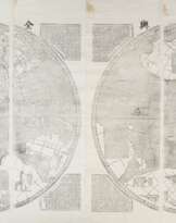
Large xylographic world map with some hand-coloring, on Japanese paper, approximately 1250 x 1220 mm, all mounted on 19th-century Japanese paper, folding in panels to 250 x 180 mm, blue paper covers. The map following the exact form of Wang Junfu’s original, with the first two characters of Wang’s title “tianxia (under heaven)” changed to “daming (the Great Ming).” The misalignment of the left and right halves of the map attributed to the printing process of the first edition, this feature also appearing in the six comparable copies mentioned above. (Some uneven toning, scattered wormholes with small losses, old restoration in lower right corner.)
Exhibited: “The World on Paper: From Square to Sphericity,” Hong Kong Maritime Museum, December 2019 to March 2020.
Please note that this lot is subject to an import tariff. If the buyer instructs Christie’s to arrange shipping of the lot to a foreign address, the buyer will not be required to pay the import tariff. If the buyer instructs Christie’s to arrange shipping of the lot to a domestic address, if the buyer collects the property in person, or if the buyer arranges their own shipping (whether domestically or internationally), the buyer will be required to pay the import tariff. Please contact Post Sale Services on +1 212 636 2650 prior to bidding for more information.
| Artist: | William Shakespeare (1564 - 1616) |
|---|---|
| Applied technique: | Pencil |
| Artist: | William Shakespeare (1564 - 1616) |
|---|---|
| Applied technique: | Pencil |
| Address of auction |
CHRISTIE'S 8 King Street, St. James's SW1Y 6QT London United Kingdom | |
|---|---|---|
| Preview |
| |
| Phone | +44 (0)20 7839 9060 | |
| Buyer Premium | see on Website | |
| Conditions of purchase | Conditions of purchase |
