


ID 627594
Lot 105 | Complete Map of the Unified Empire
Estimate value
$ 10 000 – 15 000
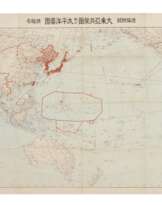
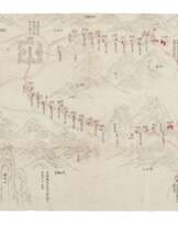
An extremely rare early version of the first monumental map of Qing China to mix Western coordinates with Chinese cartographic grids. Based on the inscription printed at the upper left corner of the map, the painter of the atlas was Dong Lifang (or Dong Youcheng, 1791-1823). The resources of this atlas are mainly the Huangyu Quanlan Tu (Overview Atlas of Imperial Territories) produced by the Kangxi court and Huangyu Quantu (Complete Atlas of the Imperial Territories) during the Qianlong reign. Apart from information from the above atlases, Dong Fangli revised his map with changes of administrative divisions from post-Qianlong period to the second year of Daoguang’s reign (1822). The map, composed of 41 individual maps of various sizes, covers an area reaching around 60 degree north at the Sino-Russian border, 20 degree east at the Sakhalin Island, 18 degree south at the Hainan Island and 44 degree west at the Pamir Mountains. For the purpose of offering the viewer a better viewing experience, famous geographer Li Zhaoluo (1769-1841) collated the individual maps into one overview map, and published the monochrome woodblock printed version in 1832. One of the most significant features of the map is that it combines the meridian and parallel lines from Western cartography with the grids used in Chinese cartography, to better accommodate readers from different backgrounds. The dotted lines represent meridian lines, while solid lines represent the grids, with the horizontal solid lines simultaneously standing for parallel lines. This innovative fusion style influenced cartographic practices of the following generations. (Hsieh and Ehrenberg) The last part of the inscription offer a cartographical guide, and the signature lines provide information of the date (1832), place (Yanghu County, Changzhou) and publisher (Li Zhaoluo’s Book Studio of Aspiration Seeking). This atlas was one of the best woodblock maps of China produced after the Kangxi and Qianlong imperial maps. A seal of Piling Wenxian Zhengcun She (Association Soliciting and Preserving Archives of Piling) is stamped on the title piece. Piling refers to the modern Changzhou, Jiangsu Province. The association is recorded publishing rare and ancient books in 1949. Also on the title piece, a stamp of two four-character vertical lines read “the price of each set is four taels of fine silver.” The same stamp is seen on the title leaf of a copy of the map reproduced by Li Zhaoluo’s student Liu Yan in 1842 in the collection of the National Palace Museum, Taipei. Apart from the 1842 version, other more commonly seen editions of this map include woodblock and lithograph reprints, as well as thread-bound book form versions in late-Qing period. Other examples of the 1832 version are rare, and can only be found in the Library of Congress (USA) and Beijing Library (China). References: Kuo-Hsin Hsieh & Ralph E. Ehrenberg, Reading Imperial Cartography: Ming-Qing Historical Maps in the Library of Congress (2013), pp. 90-93.
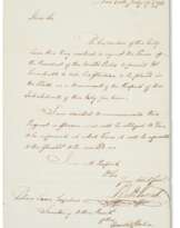
Very large hand-colored printed map of China during Daoguang period, ink and color on three-layer paper, joined and subsequently divided into eight horizontal strips folded into eight brown envelopes, each strip contains three to four separate sheets; the single sheets from approximately 325 x 855 mm to 325 x 2595 mm unfolded, folded size is 325 x 145mm; the whole map approximately 2575 x 4230 mm (or over eight by nearly 14 feet), including a title piece, a thumbnail of the whole map and two pieces of inscription, all in a Japanese wood box with brass handles and cloud-shaped hasp, approximately 380 x 210 x 125mm. Hand-painted green colors are applied for tributaries and outlines of coasts, light green for the Yangtze River, yellow for the Yellow River, and red, blue and grey for other waterways. Symbols of administrative divisions are highlighted in red. On the back of the right side, the third-column leaves are written with a Chinese numbering character at the lower right corner to indicate the sequence of the strips (the characters of number five and one are lost). (The envelopes are split, womholes along the margins and folds of both the envelopes and maps, some soiling, stains and water marks on the maps, some fold splitting, slightly toned, the rear side of the envelope for strip eight defective.) Provenance: Piling Wenxian Zhengcun She (Piling Archives, extant until the 1940s).
Please note that this lot is subject to an import tariff. If the buyer instructs Christie’s to arrange shipping of the lot to a foreign address, the buyer will not be required to pay the import tariff. If the buyer instructs Christie’s to arrange shipping of the lot to a domestic address, if the buyer collects the property in person, or if the buyer arranges their own shipping (whether domestically or internationally), the buyer will be required to pay the import tariff. Please contact Post Sale Services on +1 212 636 2650 prior to bidding for more information.
| Artist: | William Shakespeare (1564 - 1616) |
|---|---|
| Applied technique: | Pencil |
| Artist: | William Shakespeare (1564 - 1616) |
|---|---|
| Applied technique: | Pencil |
| Address of auction |
CHRISTIE'S 8 King Street, St. James's SW1Y 6QT London United Kingdom | |
|---|---|---|
| Preview |
| |
| Phone | +44 (0)20 7839 9060 | |
| Buyer Premium | see on Website | |
| Conditions of purchase | Conditions of purchase |
More from Creator
Related terms
Make a Bid
Bid by Phone Bid

| Lot number | 105 |
|---|---|
| Auction house | CHRISTIE'S |
| Auction date | 15.10.2021 |
Your bid: $ 8 000
Phones for communication:
+34827387, +232346832
This is your maximum bid, which is being transmitted to the auction house. If the maximum bid is higher than the limit price of the item, the auctioneer will bid for you up to the height of the maximum bid.
This is your maximum bid, which is being transmitted to the auctioneer. If the maximum bid is higher than the minimal price of the item, the auctioneer will bid for you up to the height of the maximum amount.
| Lot number | 105 |
|---|---|
| Auction house | CHRISTIE'S |
| Auction date | 15.10.2021 |
Bid Error
| Lot number | 105 |
|---|---|
| Auction house | CHRISTIE'S |
| Auction date | 15.10.2021 |
Вы уже сделали ставку в € 40 000 и ставка принята аукционным домом. Если вы хотите ее уменьшить, то обратитесь напрямую в администрацию аукционного дома.
Bid Error
| Lot number | 105 |
|---|---|
| Auction house | CHRISTIE'S |
| Auction date | 15.10.2021 |
Вы не можете делать ставки в данном АД, т.к. были внесены в черный список.
Make a Bid
| Lot number | 105 |
|---|---|
| Auction house | CHRISTIE'S |
| Auction date | 15.10.2021 |
Autobid is prepared
| Lot number | 105 |
|---|---|
| Auction house | CHRISTIE'S |
| Auction date | 15.10.2021 |
