ID 1119203
Lot 94 | Description de la Louisiane and Nouvelle decouverte d'un tres grand pays situe dans l'Amerique
Estimate value
$ 50 000 – 70 000
Louis Hennepin, 1683
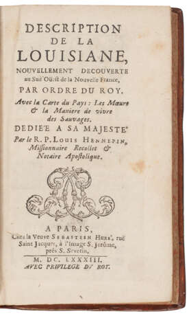
HENNEPIN, Louis (1640-1704). Description de la Louisiane, nouvellement decouverte au Sud'Ouest de la Nouvelle France. Paris: Widow of Sebastien Hure, 1683.
The first edition, first issue, of Hennepin's first work, including a very fine example of the rare and important map with an important depiction of the Mississippi. In 1675, the Belgian priest Father Louis Hennepin sailed to New France with a Franciscan Recollect mission in the same ship as René Robert Cavelier, Sieur de la Salle. From Quebec, he carried out missionary work among the Iroquois and then in 1678 joined La Salle as the expedition's chaplain. This work contains the "first account in print of La Salle’s journey to the Illinois country in 1678 and 1679, and the first [eye-witness] description in print of the Falls of Niagara, as well as the first account in print of the Mississippi above its confluence with the Wisconsin River." (Streeter). With La Salle, Hennepin continued by way of Lake Huron, Green Bay, Lake Michigan and the River St. Joseph to the River Illinois and helped establish Fort Crevecoeur. He and two others were captured by the Sioux in 1680 and accompanied them on several hunting expeditions. During one, Hennepin became the first European to encounter the Falls of St. Anthony. Daniel Greysolon Dulhut helped secure his release to the mission of St. Francis Xavier on Green Bay. He returned to France in 1682 and published this book the following year.
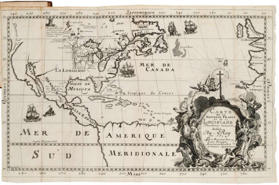
The very handsome and rare map is the first to name Louisiana and among the first to depict the Mississippi, here named the Colbert. "Hennepin pointed his 'R. Colbert' (the Mississippi) straight south, with a dotted line continuing it to the Gulf at almost the proper geographic spot, whereas LaSalle (and—as will be seen—the cartographer Franquelin and his followers) made it wander to the west and enter the Gulf near the point where LaSalle set up his colony ... [Hennepin's map], along with a quaint picture of the Great Lakes, did show a lengthy section of the Mississippi River. Here was new knowledge—vast new knowledge" (Wheat). Alden & Landis 682⁄96; Ayer 127; Howes H-415 ("c"); Sabin 31347; Streeter sale 102; Wheat Mapping the Transmississippi West, 62.
12mo (150 x 88mm). Folding engraved map, "Carte de la Nouvelle France et de la Louisiane," woodcut headpieces (closed marginal tear to ã4, a few tiny paper flaws, minor intermittent spotting, map supplied and with a 1 1⁄2 inch repaired stub tear). Contemporary calf remboîtage (restored). Custom solander box.
| Artist: | Louis Hennepin (1626 - 1704) |
|---|---|
| Place of origin: | Canada, Western Europe, France, Europe |
| Auction house category: | Printed books |
| Artist: | Louis Hennepin (1626 - 1704) |
|---|---|
| Place of origin: | Canada, Western Europe, France, Europe |
| Auction house category: | Printed books |
| Address of auction |
CHRISTIE'S 20 Rockefeller Plaza 10020 New York USA | ||||||||||||||
|---|---|---|---|---|---|---|---|---|---|---|---|---|---|---|---|
| Preview |
| ||||||||||||||
| Phone | +1 212 636 2000 | ||||||||||||||
| Fax | +1 212 636 4930 | ||||||||||||||
| Conditions of purchase | Conditions of purchase | ||||||||||||||
| Shipping |
Postal service Courier service pickup by yourself | ||||||||||||||
| Payment methods |
Wire Transfer | ||||||||||||||
| Business hours | Business hours
|


