

ID 1119148
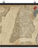
Lot 99 | Plan of the City of New York
Estimate value
$ 150 000 – 200 000
Bernard Ratzer, 1776
RATZER, Bernard (fl.1756-1777). Plan of the City of New York, in North America surveyed in the Years 1766 & 1767. London: Jefferys & Faden, 12 January 1776.
New York City at the dawn of the American Revolution. A bright, clean copy of "finest map of an American city and its environs produced in the eighteenth century" (Cohen & Augustyn, Manhattan in Maps). The map itself is a highly accurate delineation of the bustling seaport of some twenty thousand people as it existed in the late 1760s at the southern tip of Manhattan Island. Cultivated fields, forests, and salt meadows are interspersed with large estates, offering the first meaningfully detailed view of the countryside surrounding the growing city: “No earlier map provided such a detailed view of the predevelopment topography of Manhattan” (ibid). This expansive view of Manhattan from the Battery to present-day 50th Street, as well portions of Long Island, New Jersey and the islands of Upper New York Harbor, is complimented by an elaborate, panoramic view of New York City as seen from Governor's Island after a 1760 watercolor by Lt. Thomas Davies.
At the conclusion of the French and Indian War in 1763, Great Britain found itself in control of most of North America, and the government in London dispatched its most capable topographical engineers and mapmakers to survey the hard-won spoils. Several of the most significant maps of America were created during the years between the French and Indian War and the Revolution. Ratzer’s New York map is considered the jewel of this remarkable period of mapmaking. In his landmark Iconography of Manhattan Island, I. N. Phelps Stokes described this map as “one of the most beautiful, important and accurate plans of New York.”
This map's remarkable accuracy is rooted in the circumstances of its production—it was the expansion of a military survey ordered by General Thomas Gage in the wake of the Stamp Act Riots that rocked New York in the fall of 1765 (see the preceding lot). A little more than a decade later, the British captured Manhattan and the island and harbor served as their base of operations during the entire war. The Razter map would prove to be a key reference for planners on both sides of the War of Independence. Today it reminds us of New York’s often overlooked, central role in the story of the American Revolution.
Engraved map in three sheets, dissected into 15 panels (1200 x 855mm on a 1221 x 905mm sheet). Title set on lower left corner of map with decorative cartouche and list of references, one compass rose, inset scale bar, and dedication to Sir Henry Moore, Governor of New York at the upper left corner. The map surmounting an engraved panoramic view of the city from Governors island, after a 1760 view by Captain Davies. Backed with washi paper (minor losses at fold intersections, light soiling toward top margin). Hinged to linen and framed.
| Artist: | Bernard Ratzer (1700 - ?) |
|---|---|
| Auction house category: | Maps & Atlases |
| Artist: | Bernard Ratzer (1700 - ?) |
|---|---|
| Auction house category: | Maps & Atlases |
| Address of auction |
CHRISTIE'S 20 Rockefeller Plaza 10020 New York USA | ||||||||||||||
|---|---|---|---|---|---|---|---|---|---|---|---|---|---|---|---|
| Preview |
| ||||||||||||||
| Phone | +1 212 636 2000 | ||||||||||||||
| Fax | +1 212 636 4930 | ||||||||||||||
| Conditions of purchase | Conditions of purchase | ||||||||||||||
| Shipping |
Postal service Courier service pickup by yourself | ||||||||||||||
| Payment methods |
Wire Transfer | ||||||||||||||
| Business hours | Business hours
|
Related terms
Make a Bid
Bid by Phone Bid

| Lot number | 99 |
|---|---|
| Auction house | CHRISTIE'S |
| Auction date | 17.01.2024 |
Your bid: $ 150 000
Phones for communication:
+34827387, +232346832
This is your maximum bid, which is being transmitted to the auction house. If the maximum bid is higher than the limit price of the item, the auctioneer will bid for you up to the height of the maximum bid.
This is your maximum bid, which is being transmitted to the auctioneer. If the maximum bid is higher than the minimal price of the item, the auctioneer will bid for you up to the height of the maximum amount.
| Lot number | 99 |
|---|---|
| Auction house | CHRISTIE'S |
| Auction date | 17.01.2024 |
Bid Error
| Lot number | 99 |
|---|---|
| Auction house | CHRISTIE'S |
| Auction date | 17.01.2024 |
Вы уже сделали ставку в € 40 000 и ставка принята аукционным домом. Если вы хотите ее уменьшить, то обратитесь напрямую в администрацию аукционного дома.
Bid Error
| Lot number | 99 |
|---|---|
| Auction house | CHRISTIE'S |
| Auction date | 17.01.2024 |
Вы не можете делать ставки в данном АД, т.к. были внесены в черный список.
Make a Bid
| Lot number | 99 |
|---|---|
| Auction house | CHRISTIE'S |
| Auction date | 17.01.2024 |
Autobid is prepared
| Lot number | 99 |
|---|---|
| Auction house | CHRISTIE'S |
| Auction date | 17.01.2024 |
