ID 627558
Lot 68 | Theatrum orbis terrarum
Estimate value
$ 100 000 – 150 000
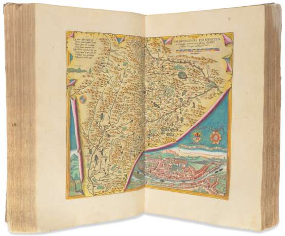
The first modern world atlas, hand-colored and heightened in gold—the watershed of Renaissance cartography. Ortelius's atlas "set a standard by which subsequent collections would be judged and compared" (Short). The major innovation of the Theatrum was to provide, in a single volume, accurate modern maps in a uniform, regular format, together with explanatory text. It was the most expensive book of its day, and yet also one of the bestsellers, going into 37 editions and 7 languages. The first edition came out in 1570 with 50 maps, and as cartographic knowledge increased, so did the number of maps in each subsequent edition. Plantin took over publication of new editions in 1579 and began to incorporate the supplemental Parergon and Nomenclator Ptolemaicus. The maps and plates in the Parergon may be considered "the most outstanding engravings depicting the wide-spread interest in classical geography in the 16th century" (Van der Krogt).
The present edition contains 108 maps in the Theatrum as well as the 26 maps and views of the Parergon, all in contemporary hand-coloring. It has an early Spanish provenance, with marginal comments in Spanish and Latin. The text on the map of Valencia has been censored with a patch, erasing the text on the practice of Islam in Spain; this is the final edition of the text in which this passage appeared. New to this edition are the maps of Flanders and Brabant.
Perhaps second only to his friend Mercator in influence and importance, Ortelius spent his life in the international merchant city of Antwerp as a mapmaker, seller, and collector. A prolific correspondent and important link between the worlds of not only the merchant and the scholar but also of the artist, he was committed to creating usable and up-to-date maps drawn from the newest data available to him. Instead of a historical description of the world as passed down by tradition, his atlas was a picture of the known world in the present. This is not to say, however, that the Theatrum is not learned or based on knowledge of tradition—the text provides detailed discussions of each map which cite both ancient and modern authorities, marrying the ancient geographers with the new eye-witness accounts of Coronado, Cartier, Thevet, and more. Notably, he gives credit generously to those whose data he uses; the first edition names 87 sources, with more added in each edition.
The Theatrum orbis terrarum is a cartographic expression of the Renaissance republic of letters, building communal knowledge of the world and disseminating it through print. The title of the atlas, the "Theater of the Earth," references the idea of the theater of nature, in which God's laws play out for a human audience. It is "a title that announces encyclopedic intentions of surveying all of nature to provide complete and ordered coverage" (Short), providing a mirror of nature for the service of humanity. This idea achieved such broad cultural penetration that Shakespeare's 1599 play As You Like It would declare that "All the world's a stage."
Ortelius's Antwerp was not only an intellectual hotbed, but an economic one; its history is closely woven with that of the "Age of Exploration" and the rise of global colonial trade networks. For the first half of Ortelius's life, Antwerp was a main shipping base for Portuguese spice merchants, who traded for English cloth, German wine, and Baltic wheat. It was also the sugar capital of Europe, where sugar produced by enslaved laborers on plantations in the Americas was processed and then sold on to other European cities. This was the vibrant and wealthy context of Ortelius's Theatrum, whose allegorical frontispiece depicts the personification of Europe ruling over those of Asia, Africa, and America—with a faceless marble bust signifying lands yet unknown.
When unrest caused by the Eighty Year's War and the Dutch Revolt cut Antwerp and the rest of the Low Countries off from Portuguese trade, this planted the seeds of a major force in the century to come: The Dutch East India Company. The need to identify and secure their own maritime trade routes cemented the importance of cartographic projects like that of Ortelius. Indeed, one of Ortelius's correspondents and sources was Jan Huyghen van Linschoten, whose knowledge of secret Portuguese trade routes would become key to unlocking Dutch trade supremacy. In many editions and many languages, Ortelius's atlas provided accurate geographic information to audiences across Europe, fueling the battle for trade supremacy—and keeping the book in print for over a century. The Spanish marginalia in this copy attests to its practical use for those interested in the products on offer by the ever-growing known world to those with means to master the trade routes and supply lines between them. Koeman Ort 27B; Van der Krogt 31. See also John Rennie Short, Making Space: Revisioning the World, 1475-1600 (2004).
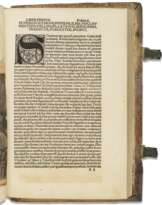
Three parts in one volume, folio (440 x 292mm). Hand-colored engraved title page heightened in gold, hand-colored portrait of Ortelius, 108 hand-colored double-page maps, hand-colored woodcut title of Parergon, 26 hand-colored double-page maps and views, woodcut initials and tailpieces throughout with some hand-colored (old patch to upper outer corner of first title with a few repaired tears strengthened at inner margin, a few maps with splits at fold, maps 71 and 72 with larger tear and missing small slice of lower edge of map, occasional offsetting or pigment browning to some engravings, some light stains and fingersoiling around edges, some worming in the gutter at the end). Old vellum over pasteboard, title in ink on spine (corners showing, dustsoiled, foot of spine fraying). Provenance: Ruperto de Zafra (inscription on title page and marginalia in Spanish and Latin).
| Artist: | William Shakespeare (1564 - 1616) |
|---|---|
| Applied technique: | Pencil |
| Artist: | William Shakespeare (1564 - 1616) |
|---|---|
| Applied technique: | Pencil |
| Address of auction |
CHRISTIE'S 8 King Street, St. James's SW1Y 6QT London United Kingdom | |
|---|---|---|
| Preview |
| |
| Phone | +44 (0)20 7839 9060 | |
| Buyer Premium | see on Website | |
| Conditions of purchase | Conditions of purchase |


