 and Jan BLAEU (1596-1673) - photo 1")
 and Jan BLAEU (1596-1673) - photo 2")
 and Jan BLAEU (1596-1673) - photo 3")
 and Jan BLAEU (1596-1673) - photo 4")
 and Jan BLAEU (1596-1673) - photo 5")
 and Jan BLAEU (1596-1673) - photo 6")
 and Jan BLAEU (1596-1673) - photo 7")

ID 1249834
Lot 110 | BLAEU, Willem (1571-1638) and Jan BLAEU (1596-1673)
Estimate value
£ 250 000 – 350 000
Grooten Atlas [Atlas Major]. Amsterdam: Johannes Blaeu, 1664.
A particularly fine copy of the most famous atlas in the history of printed maps. Since its publication, the Blaeu Atlas Major has remained, with every justification, the most magnificent work of its kind ever produced. The present set is coloured throughout by a contemporary hand and heightened in gold, containing some 200 maps more than the largest editions of Blaeu's next most expansive atlas, the Theatrum Orbis Terrarum.
The Atlas Major is the epitome of decades of achievement by the Blaeu family. Published in five languages (Latin, Dutch, French, German and Spanish) from 1662, this comprehensive atlas was, as Koeman observes, a 'costly atlas ... exclusively designed for those members of the patriciate who could command both the material and intellectual resources that were needed to buy and appreciate it'.
This example is the Dutch edition, which is arranged quite differently from the Latin or French editions. It has its origins in Willem Blaeu's intention to publish a new 'international edition' of a world atlas, which was first announced on 11 February 1634 in an Amsterdam newspaper, the Courante uyt Italien ende Duytschlandt. This was a 2-volume atlas published in 4 languages, with the German edition being the first to appear in 1634, and the Latin, Dutch and French appearing in 1635. The first part of its Latin title, Theatrum Orbis Terrarum, deliberately echoed the previous efforts of Abraham Ortelius, while the following part of the title, Atlas Novus, spelled out that this was a new publication at the fore-front of cartographic knowledge.
Willem planned another 2 additional volumes, but these were only completed after his death, in 1640 and 1645. Willem's son, Jan, progressively expanded the Atlas Novus to six volumes by 1655, and this formed the first half of the Atlas Major. The Dutch edition, entitled Tooneel des Aerdrycks, is the most complicated in make-up, with the text being reset at least 4 times. Since it was the basis for the Grooten Atlas [Atlas Major] this has led to quite a different composition from the other language editions. For instance, while the Latin editions carry a uniform date, the present lot varies considerably, with volumes 1-3 and 9 dated 1664, volume 7 is undated, while volumes 4-6 reuse Toonneel titles and are dated 1648, 1654, and 1650 respectively.
As Van der Krogt explains: 'Joan Blaeu probably had a large stock of printed sheets of his latest Toonneel des Aerdrycks and did not want to discard them, nor to change in manuscript all the signatures and map numbers. Therefore he gave the maps, which were appearing in the Grooten Atlas for the first time, signatures and numbers which fitted them into those of the Toonneel... In this way volumes 1 to 3 of the Grooten Atlas are compiled from volume 1 of the Toonneel; volume 6 from part 1 of volume 2 of the Toonneel; volume 7 from volume 3; volume 8 from part 2 of volume 2 (except Asia); and volume 9 from the maps of Asia part 2 of volume 2, to which the atlas of China (volume 6 of the Toonneel) was added. Volumes 4 and 5 are identical to their corresponding volumes of the Toonneel' (II, p.383).
The present lot seems to be one of the early variants identified by Van der Krogt, updating early editions of volumes 4, 7 and 9 from the Toonneel (see Van der Krogt II, p.383).
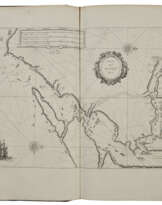
Volume I [Northern Europe, Scandinavia, Russia]. Erste Stuck der Aerdrycks Beschryving, welck vervat de Landen onder de Noordpool, en de Noorderdeeken van Europa. 1664. Engraved frontispiece, 91 maps and plates, all double-page, excepting 11 single-page and 7 in the text, collating as per Van der Krogt but the addition of folding map 'Campus Inter Bohum' in the Russian part (half-title 'Aerdkloots-bescryving' with vertical creasing and 50mm horizontal tear in lower margin due to paper flaw, but without loss, world map and a few others lightly creased at centrefold). Van der Krogt 2:621.1. Includes the important world map, of which Shirley observes: 'As with all productions of the firm of Blaeu, the engraving and layout are all of the highest standard' (Shirley, Mapping the World 428).
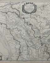
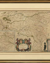
Volume II [Germania and Switzerland]. Tweede Stuck ... Duytslandt. 1664. 107 engraved maps, 3 of which folding, all but one double-page (title and map 1 with some vertical creasing, map 1 with very small repair to extremity of top margin, map 9 'Marchionatus Brandenburgici partes duae, Nova Marchia et Uckerana' supplied from another edition with blank versos and inserted between maps 6 and 7, map 12 'Ducatus Brunsvicensis' with large vertical taped repair on verso, tiny hole with old repair in border of map 78 'Territorii Novoforensis', map 82 'Sveviae Nova Tabula' with short repair to vertical fold, folding map 94 'Alsatia Landgraviatus' spotted with brown ink, a few text leaves lightly browned). Van der Krogt, 2:621.2.
Volume III [The Low Countries]. Derde Stuck ... Nederlanden. 1664. 2 engraved titles and 65 maps, 4 of which in the text, all the other double-page including one folding (map 19 'Episcopatus Gandavenis' with repaired tear into image, some browning to text leaves towards end). Collates as per Van der Krogt, 2:621.3, but with the original signatures to maps 16 and 17 (as per Van der Krogt 2:222.1LM) and maps 36 and 37 (2:221-4).
Volume IV [England and Wales]. Vierde Stuck ... Engelandt. 1648 [but 1664]. Engraved pictorial title 58 maps, all but one double-page, and 3 views in the text of Stonehenge, the Rollright Stones near Eynsham, and Subterranean holes near Tilbury (light browning to maps 53 and 54 of Westmoreland and Cumberland). Van der Krogt 2:321.
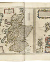
Volume V [Scotland]. Vyfde Stuck ... Schotlandt en Yrlandt. 1654 [but 1664]. Engraved pictorial title and 55 maps, all but one double-page (some browning affecting the preliminary text leaves as well as maps 7 and 17 which are both also creased). Van der Krogt 2:422.
Volume VI [France]. Seste Stuck ... Vranckryck. 1650 [but 1664]. Engraved title with printed overslips, 66 double-page maps, one of which folding (large folding map 'Imperii Caroli Magni' browned with some old repairs and tiny holes mainly at creasefolds, browning to map 60 and 5 text leaves). Van der Krogt 2:621.6
Volume VII [Italy and Greece]. Sevende Stuck ... Italien en Griecken. [1664]. Engraved title with printed overslip, and 67 hand-coloured maps comprising 63 double-page, one single-page and 3 in the text (a clean volume, collating as per the 1642 ed. of the Toonneel, but the 5 maps from the Grooten Atlas inserted for a full complement, viz: 'Corsica Insula', 'Ducatus Braccianus', Insulae Termitanae', 'Cyclades Insulae' and 'Maris Aegaei', and with text leaves L-M and index leaf at end). Van der Krogt, 2:221.3 and 2.621.7
Volume VIII [Spain, Africa and America]. Achtste Stuck ... Spaenjen, Africa en America. 1650 [but 1665 on part-titles]. 2 letterpress part-titles, engraved title and 64 double-page maps and plates, one of which folding (light browning to the Africa part, tiny split to centrefold of map 31 'Melite Insula', some light creasing along vertical centrefolds more heavily affecting map 40 'Aethiopia Inferior'). Van der Krogt 2:621.8
Volume IX [Asia]. Negende Stuck ... Asia en Sina. 1664. Letterpress title, engraved title to part one and letterpress part-title to part 2, 27 engraved double-page maps, engraved title imprint and first 10 maps conforming to the Asia section of part 2 of volume 2 of the 1642 Toonneel but without 'China Veteribus Sinarum Regio', the following 17 maps, all conforming to the Novus Atlas Sinensis (some light spotting and browning throughout, index leaf with 50mm marginal tear repaired on verso). Van der Krogt 2:221.2 and 2:521.
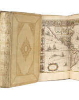
9 volumes, folio (510 x 335mm). 600 engraved maps coloured by a contemporary hand and heightened with gold throughout. Original publisher’s vellum, panelled in gilt with central device of Atlas holding a celestial globe surrounded by ornate foliate tooling, green silk ties (some loose, a few missing).
| Artist: | Jan Willemsz. Blaeu (1596 - 1673) Willem Janszoon Blaeu (1571 - 1638) |
|---|---|
| Place of origin: | Western Europe, Europe, The Netherlands |
| Auction house category: | Maps & Atlases, Books and manuscripts |
| Artist: | Jan Willemsz. Blaeu (1596 - 1673) Willem Janszoon Blaeu (1571 - 1638) |
|---|---|
| Place of origin: | Western Europe, Europe, The Netherlands |
| Auction house category: | Maps & Atlases, Books and manuscripts |
| Address of auction |
CHRISTIE'S 8 King Street, St. James's SW1Y 6QT London United Kingdom | |
|---|---|---|
| Preview |
| |
| Phone | +44 (0)20 7839 9060 | |
| Buyer Premium | see on Website | |
| Conditions of purchase | Conditions of purchase |
More from Creator


Related terms
Make a Bid
Bid by Phone Bid
 and Jan BLAEU (1596-1673) - photo 1")
| Lot number | 110 |
|---|---|
| Auction house | CHRISTIE'S |
| Auction date | 10.07.2024 |
Your bid: £ 250 000
Phones for communication:
+34827387, +232346832
This is your maximum bid, which is being transmitted to the auction house. If the maximum bid is higher than the limit price of the item, the auctioneer will bid for you up to the height of the maximum bid.
This is your maximum bid, which is being transmitted to the auctioneer. If the maximum bid is higher than the minimal price of the item, the auctioneer will bid for you up to the height of the maximum amount.
| Lot number | 110 |
|---|---|
| Auction house | CHRISTIE'S |
| Auction date | 10.07.2024 |
Bid Error
| Lot number | 110 |
|---|---|
| Auction house | CHRISTIE'S |
| Auction date | 10.07.2024 |
Вы уже сделали ставку в € 40 000 и ставка принята аукционным домом. Если вы хотите ее уменьшить, то обратитесь напрямую в администрацию аукционного дома.
Bid Error
| Lot number | 110 |
|---|---|
| Auction house | CHRISTIE'S |
| Auction date | 10.07.2024 |
Вы не можете делать ставки в данном АД, т.к. были внесены в черный список.
Make a Bid
| Lot number | 110 |
|---|---|
| Auction house | CHRISTIE'S |
| Auction date | 10.07.2024 |
Autobid is prepared
| Lot number | 110 |
|---|---|
| Auction house | CHRISTIE'S |
| Auction date | 10.07.2024 |
