ID 627589
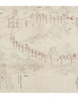
Lot 100 | Coastal Control of Guangdong
Estimate value
$ 30 000 – 50 000
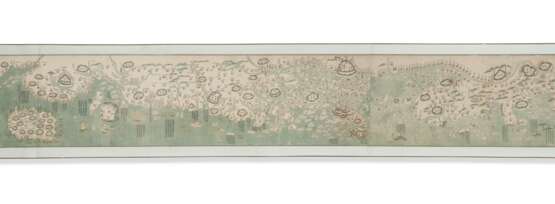
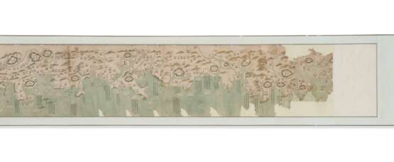
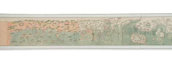
Important manuscript map depicting Guangdong's coast before the Opium Wars. Executed in the form of a handscroll, the map starts from the area around Pengzhou Suo (Pengzhou Fortress, present-day Shantou, Guangdong Province), and ends at the Annam Kingdom (modern-day Vietnam), a tributary of Qing China. No orientation or legend is given, but north is obviously at the top, and symbols and colors are consistently applied throughout the map. China’s territory is left uncolored, while the foreign territories are filled with pink-orange.
Although the name of the Annam Kingdom was changed to Vietnam in 1803, the map was most probably painted between 1810 and 1817. The Tung Lung Fort (or South Buddhist Shrine) abandoned its cannons in 1810, and consequently the fort is depicted without a barbette symbol (Tam). Similarly, Taiwong Fort in Guangzhou, an important fortress in which gun emplacements were constructed in 1817, based on Ruan Yuan’s (1764-1789) proposal, also lacks the name and symbol of barbette, implying the present lot was executed before 1817. The refined painting and calligraphy suggest the authorship of an government cartographer (Tam). For maps of similar style and produced in the same period, see Map of the Waterways in Guangdong Province dated to 1812-1816, from the collection of the Geography and Map Divisions of the Library of Congress, US. Although the two maps are by different hands, the color scheme and design of visual elements are alike. General Map of Guangdong Province, from the same collection, is another comparable map of Guangdong, also produced during the Jiaqing period in 1816. References: Kwong-Lim Tam, Cong Fangyuan dao Jingwei: Xianggang yu Huanan Lishi Ditu Zhencang [From Circular and Square Shapes to Meridian and Parallel Lines: Collected Treasures of Historical Maps of Hong Kong and South China] (2010), pp. 71-72, pl. 32; Kuo-Hsin Hsieh & Ralph E. Ehrenberg, Reading Imperial Cartography: Ming-Qing Historical Maps in the Library of Congress (2013), pp. 281.
Manuscript map of Guangdong coasts in the form of a long handscroll mounted on silk, ink and colors on paper, edged in pale green silk with white patterns, with chartreuse silk protective wrapper, rolled on a bamboo roller, approximately 365 x 4690 mm overall, contained in a 90 x 570 x 65mm wooden box with sliding lid. All inscriptions are written in Chinese, including place names and annotations of important harbors, specifying the water depth, the harbor’s distance mileage to the neighboring town, and the distance from the town to its garrison; all with ink outlines, waters in pale green, mountains in green gradient, lands in the last section in pale orange, architecture with green roofs or walls and red gates, numerous houses, pagodas, temples, pavilions, barracks, barbettes, watch-towers and checkpoints clearly marked in detail. The distribution of towns and checkpoints is intensive and dense, and is represented by the symbol of a single house. Above county level, places are circled with symbols of four gates. (Paper slightly toned, colors lightly faded, wears along the upper margin, a few damp-stains and surface abrasions, areas of patched loss at the upper and lower parts of the opening section; five large tears at the lowermost portions of the first and second sheets, not affecting the contents of the map; occasional light staining to the surface and to margins of the silk mountings.) Provenance: China Guardian, 23 April 2002, lot 1466.
Exhibited: “The World on Paper: From Square to Sphericity,” Hong Kong Maritime Museum, December 2019 to March 2020.
Please note that this lot is subject to an import tariff. If the buyer instructs Christie’s to arrange shipping of the lot to a foreign address, the buyer will not be required to pay the import tariff. If the buyer instructs Christie’s to arrange shipping of the lot to a domestic address, if the buyer collects the property in person, or if the buyer arranges their own shipping (whether domestically or internationally), the buyer will be required to pay the import tariff. Please contact Post Sale Services on +1 212 636 2650 prior to bidding for more information.
| Artist: | William Shakespeare (1564 - 1616) |
|---|---|
| Applied technique: | Pencil |
| Artist: | William Shakespeare (1564 - 1616) |
|---|---|
| Applied technique: | Pencil |
| Address of auction |
CHRISTIE'S 8 King Street, St. James's SW1Y 6QT London United Kingdom | |
|---|---|---|
| Preview |
| |
| Phone | +44 (0)20 7839 9060 | |
| Buyer Premium | see on Website | |
| Conditions of purchase | Conditions of purchase |
