


ID 627588
Lot 99 | Manuscript map of the Ryukyu Kingdom
Estimate value
$ 1 500 – 2 500
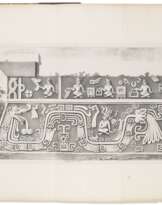
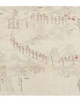
Fascinating manuscript trade route map of the Ryukyu Kingdom, showing the southern tip of mainland Japan around Kagoshima, the archipelago of the Ryukyu Kingdom and the east coast of mainland China. The original map was designed by Hayashi Shihei (1738-1793) and published in his Sangoku Tsūran Zusetsu (An Overall Illustrated Description of Three Countries) in 1785. Among the extant early versions (Edo period), a copy in the Waseda University Library applies a palette similar to that of the present lot. The Ryukyu Kingdom was a kingdom in the Ryukyu Islands from 1429 to 1879. The king of Ryukyu paid tributes to both the Qing court and the Tokugawa court from the 1660s, and for nearly two hundred years, the Ryukyu Kingdom thrived as a key player in maritime trade with Southeast and East Asia, and a trading post for the exchange of goods from China and Japan, as Japanese were not allowed to trade with Chinese directly. This situation lasted till Emperor Meji united Japan in 1872, when the Islands were incorporated into Japan and became a prefecture in 1879. This fascinating map indicates how under Emperor Meiji’s reign, the trade routes began to open up officially. These routes are drawn with trembling wavy lines, with Chinese annotations specifying the distance mileage. The text at the lower right corner states Ryukyu Kingdom’s administrative divisions, official ranks and history.
Manuscript map of Ryukyu Kingdom, ink and color on thin rice paper, texts in Chinese and Japanese with multiple orientations, four sheets of paper joined together, approximately 739 x 300 mm overall. The title is written on a slip of thicker white paper attached to the back upside down. Two pasted slips of thin paper on the front side rectifying the name of Fujian Province and Diaoyutai (Yunkunjima, or Uotsuri-shima). Latitudes are marked out along the right edge, and the Tropic of Cancer from the left side crossing Guangdong and Taiwan. (Some minor discolorations, wormholes and surface abrasions, a few tears at folds.)
Please note that this lot is subject to an import tariff. If the buyer instructs Christie’s to arrange shipping of the lot to a foreign address, the buyer will not be required to pay the import tariff. If the buyer instructs Christie’s to arrange shipping of the lot to a domestic address, if the buyer collects the property in person, or if the buyer arranges their own shipping (whether domestically or internationally), the buyer will be required to pay the import tariff. Please contact Post Sale Services on +1 212 636 2650 prior to bidding for more information.
| Artist: | William Shakespeare (1564 - 1616) |
|---|---|
| Applied technique: | Pencil |
| Artist: | William Shakespeare (1564 - 1616) |
|---|---|
| Applied technique: | Pencil |
| Address of auction |
CHRISTIE'S 8 King Street, St. James's SW1Y 6QT London United Kingdom | |
|---|---|---|
| Preview |
| |
| Phone | +44 (0)20 7839 9060 | |
| Buyer Premium | see on Website | |
| Conditions of purchase | Conditions of purchase |
More from Creator
Related terms
Make a Bid
Bid by Phone Bid

| Lot number | 99 |
|---|---|
| Auction house | CHRISTIE'S |
| Auction date | 15.10.2021 |
Your bid: $ 1 000
Phones for communication:
+34827387, +232346832
This is your maximum bid, which is being transmitted to the auction house. If the maximum bid is higher than the limit price of the item, the auctioneer will bid for you up to the height of the maximum bid.
This is your maximum bid, which is being transmitted to the auctioneer. If the maximum bid is higher than the minimal price of the item, the auctioneer will bid for you up to the height of the maximum amount.
| Lot number | 99 |
|---|---|
| Auction house | CHRISTIE'S |
| Auction date | 15.10.2021 |
Bid Error
| Lot number | 99 |
|---|---|
| Auction house | CHRISTIE'S |
| Auction date | 15.10.2021 |
Вы уже сделали ставку в € 40 000 и ставка принята аукционным домом. Если вы хотите ее уменьшить, то обратитесь напрямую в администрацию аукционного дома.
Bid Error
| Lot number | 99 |
|---|---|
| Auction house | CHRISTIE'S |
| Auction date | 15.10.2021 |
Вы не можете делать ставки в данном АД, т.к. были внесены в черный список.
Make a Bid
| Lot number | 99 |
|---|---|
| Auction house | CHRISTIE'S |
| Auction date | 15.10.2021 |
Autobid is prepared
| Lot number | 99 |
|---|---|
| Auction house | CHRISTIE'S |
| Auction date | 15.10.2021 |
