 - photo 1")
 - photo 2")

ID 993224
Lot 214 | HUANG, Qianren (1694-1771)
Estimate value
£ 50 000 – 80 000
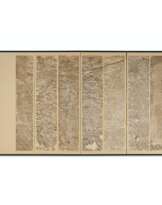
Daqing Wannian Yitong Tianxia Quantu [Complete Map of the Everlasting Great Qing with All under Heaven Unified]. China: Jiaqing period, 1814.
Extremely rare variant of the famous ‘Blue Map’ of the world vividly printed in green and orange. The cartographer of the original map, Huang Qianren (1694-1771), from Yuyao, Zhejiang Province, was the grandson of Confucianist scholar and cartographer Huang Zongyi (1610-1695), who produced Yudi Zongtu (Complete Map of China), a significant source of Huang Qianren’s map. This original map was probably executed in 1767, although no example of it now survives. However, a manuscript copy of the map was produced in 1800 which now resides in the Beijing National Library. A revised and enlarged woodblock-printed version was produced in a prototype version in 1803 (see Christie's 15 December 2021, lot 172), and then in it's better-known form sometime around 1811. This latter was published in two versions, one in black and white, and the other in blue (see Christie's 12 December 2018, lot 191). The present lot is a slightly later variant based on those blocks engraved by the Fengchitang in Minxian County of Fuzhou Prefecture (described in note in left margin of the map).
Uniquely printed utilising both a ‘yin’ (relief) and ‘yang’ (intaglio) method of woodblock engraving, the areas that appeared as white in the previous black and blue maps appear on this map in black. Other differences include the depiction of waves, the colours of the houses, and the formatting of the longer texts. At the end of the foreword, written underneath the title, the date of production is given as the first day of the chrysanthemum month (September) in the nineteenth year under the reign of emperor Jiaqing (1760-1820, r. 1796-1820), i.e. 1814.
The title of the map is as much a political statement, as it is a geographical record, celebrating the ‘unified status of all Chinese borders’ (Pegg). Besides its grand political statement, the map also had a utilitarian purpose to aid in the administration of the empire, and its surface swarms with numerous administrative details and named symbols. The physical geography is represented with mountains, deserts, rivers and coast lines all articulately depicted, as is the mid-Qing era Great Wall with its checkpoints. The map focuses on two rivers, the Yellow and the Yangtze. The origin of the Yellow River is drawn correctly; however, the map still shows Minjiang River as the source of the Yangtze River, which repeats the old legend and is not correct. ‘[This] “complete” map minimizes the European notion of a map of the world, its centralized and marginalizing construct confirming the Qing/Chinese notion of the Central Kingdom’ (Pegg). Although Russia, India, Thailand, Vietnam, Japan and Korea are clearly defined (especially the latter which has a large textual commentary, indicating its status as the chief vassal state), there are no international borders: ‘The intentionally vague geopolitical lines of the [empire’s] frontiers and beyond clearly indicate the Qing’s perception of the world around them ... All foreign entities simply inhabited the fringes of the empire’ (Pegg). To the upper left of the map lie both the Mediterranean (‘Small Western Ocean’), and Atlantic (‘Great Western Ocean’), with both the Netherlands and Great Britain shown as islands. Reading Imperial Cartography: Ming-Qing Historical Maps in the Library of Congress (2013), pp. 88-89; Richard Pegg, Cartographic Traditions in East Asian Maps (2014) pp.8-9, 18-26; Richard Smith, Chinese Maps: Images of ‘All Under Heaven’ (1996); Guoqiang Bao, ‘Qing Jiaqing Taben Daqing Wannian Yitong Dili Quantu Banben Kaoshu (Investigation and Summarization of the Rubbing Complete Geographical Map of the Everlasting Unified Great Qing Produced during Jiaqing’s Reign, Qing Dynasty),’ Wenjin Academic Journal, no. 00 (2015), pp. 245-254.
Large woodblock map of China, ink and colour printed on paper, originally printed in 8 strips, here dissected in 24 sections, and mounted on modern linen, the whole measuring approximately 1400 x 2400mm. Title in strip one (reading from right to left), with an inscription containing the date of production below. The Great Wall, mountains and rivers coloured in different shades of green, the Gobi Desert – depicted in a series of dots – and the islands and countries on the fringes of the map coloured in orange. Place names and commentaries of important places are all given in Chinese.
Special notice
No VAT is payable on the hammer price or the buyer's premium for this lot. Please see the VAT Symbols and Explanation section of the Conditions of Sale for further information
| Artist: | Qianren Huang (1694 - 1771) |
|---|---|
| Place of origin: | China, Eastern Asia, Asia |
| Auction house category: | Maps & Atlases |
| Artist: | Qianren Huang (1694 - 1771) |
|---|---|
| Place of origin: | China, Eastern Asia, Asia |
| Auction house category: | Maps & Atlases |
| Address of auction |
CHRISTIE'S 8 King Street, St. James's SW1Y 6QT London United Kingdom | |
|---|---|---|
| Preview |
| |
| Phone | +44 (0)20 7839 9060 | |
| Buyer Premium | see on Website | |
| Conditions of purchase | Conditions of purchase |
Related terms
Make a Bid
Bid by Phone Bid
 - photo 1")
| Lot number | 214 |
|---|---|
| Auction house | CHRISTIE'S |
| Auction date | 12.07.2023 |
Your bid: £ 50 000
Phones for communication:
+34827387, +232346832
This is your maximum bid, which is being transmitted to the auction house. If the maximum bid is higher than the limit price of the item, the auctioneer will bid for you up to the height of the maximum bid.
This is your maximum bid, which is being transmitted to the auctioneer. If the maximum bid is higher than the minimal price of the item, the auctioneer will bid for you up to the height of the maximum amount.
| Lot number | 214 |
|---|---|
| Auction house | CHRISTIE'S |
| Auction date | 12.07.2023 |
Bid Error
| Lot number | 214 |
|---|---|
| Auction house | CHRISTIE'S |
| Auction date | 12.07.2023 |
Вы уже сделали ставку в € 40 000 и ставка принята аукционным домом. Если вы хотите ее уменьшить, то обратитесь напрямую в администрацию аукционного дома.
Bid Error
| Lot number | 214 |
|---|---|
| Auction house | CHRISTIE'S |
| Auction date | 12.07.2023 |
Вы не можете делать ставки в данном АД, т.к. были внесены в черный список.
Make a Bid
| Lot number | 214 |
|---|---|
| Auction house | CHRISTIE'S |
| Auction date | 12.07.2023 |
Autobid is prepared
| Lot number | 214 |
|---|---|
| Auction house | CHRISTIE'S |
| Auction date | 12.07.2023 |
