Gerardus Mercator, birth name Gheert Cremer was a Flemish geographer and cartographer, best known for the map projection that bears his name.
Gerardus Mercator was the first to use this equiangular cylindrical projection for drawing a navigational chart of the world on 18 sheets (1569). The Mercator projection is remarkable in that it does not distort angles and shapes and only keeps distances at the equator. It is currently used for nautical navigational and aeronautical charts. Although modern historical cartographic research has established that this projection was used as early as 1511, it is only by Mercator that it has become widely used.
The website has 5 types of users with different functions. Choose a suitable one from the list. Use the help tips that are attached to each of the user type.
Buyer
Artist and designer
Please, enter your email address with which you registered. You will receive a link to this address for changing the password.
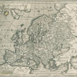


 and Jodocus HONDIUS (1563-1611)")
, Editio Quinta, 1623 (Jodocus Hondius)")