Henry Mouzon II (1741 - 1807)

Henry Mouzon II
William Henry Mouzon, Jr. was an American cartographer and civil engineer.
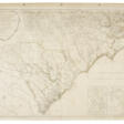
Henry Mouzon, Jr. was the grandson of a Huguenot immigrant and was sent to France at the age of eight, where he was trained as a civil engineer and surveyor. In 1771 he and Ephraim Mitchell were sent to survey the boundaries of South Carolina. As a result, a map was created and published in 1775 that included both North and South Carolina with corrections to previous maps.
This map was entitled "An Accurate Map of North and South Carolina with their Indian Boundaries," and clearly showed all the mountains, rivers, swamps, marshes, bogs, bays, creeks, harbors, sandbanks and shoals on the coasts, and gave the names of the land owners. American, British, and French troops used this map during the American Revolution. A copy of this map, owned by George Washington, is now in the library of the American Geographical Society.
| Date and place of birt: | 18 june 1741, South Carolina, USA |
|---|---|
| Date and place of death: | 25 august 1807, USA |
| Period of activity: | XVIII, XIX century |
| Specialization: | Cartographer, Engineer, Geographer |