Engineers USA


Johann Wilhelm Gerhard von Brahm, also known as John William Gerard de Brahm, was a German cartographer, military engineer, and surveyor who worked for Great Britain to develop the lands of the New World.
His father was court musician to the Elector of Trier and gave his son an excellent early education. After a successful career as a military engineer in the Bavarian army, de Brahm traveled to Georgia in 1751 at the head of a group of German emigrants. There he displayed his talents as a surveyor and engineer, worked as a cartographer, and was commissioned by South Carolina Governor James Glen to design and build a system of fortifications for Charleston.
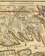
In 1755 de Brahm was appointed inspector general of lands for South Carolina and soon for the entire New World. He settled in St. Augustine, where he spent the next six years researching and preparing maps. His major works, "Map of South Carolina" and "Map of South Carolina and Part of Georgia," provide detailed topography and even describe underwater features. And his "Report of a General Survey of the Southern District of North America" records every detail from tide times to tips on tilling the soil. De Brahm's book The Atlantic Pilot, an instruction manual for sailing in Florida, was published in London and included the first published map of the Gulf Stream.


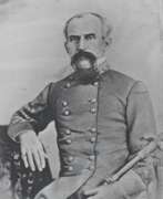
Arsène Lacarrière Latour, full name Géraud Calixte Jean Baptiste Arsène Lacarrière Latour, was a French-born American engineer and military officer, architect and surveyor, and writer.
He studied architecture and engineering at the Académie des Beaux-Arts in Paris and served briefly in the French Army Corps of Engineers. In 1805 Latour came to New York, where he worked first as a merchant, then as an architect and surveyor, and opened an architectural firm in New Orleans. In 1812. Latour became a U.S. citizen.
In 1814. Latour became Andrew Jackson's military engineer and made an important contribution to the American victory at the Battle of New Orleans. After the war ended, Latour published a book, Historical Memoirs of the War in West Florida and Louisiana, 1814-1815, which is still valued for its eye-witness view of the war.
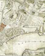
In 1816. Latour traveled with Jean Lafitte on an expedition to survey and map the Southwest as an agent for Spain. From 1818 to 1834 he worked as an architect in Havana. His manuscripts include an extensive report describing Havana's thriving economy in 1815-1821, local agricultural production (sugar cane, coffee, tobacco), trade with Europe, the United States, and the colonies of South America; statistics; and a section on the city's possible future expansion and growth. Latour subsequently returned to France, where he died.
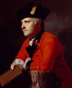

John Montresor was a British military engineer and cartographer who worked in North America.
His father was a military engineer and his youth was spent in British Gibraltar. Montresor studied in London, and in 1754 accompanied his father to North America when he was appointed chief engineer to Major General Edward Braddock's troops. John participated in various expeditions, delivered dispatches, and witnessed the sieges of Louisbourg and Quebec. During his service, he also did the necessary research and prepared maps of Acadia, the St. Lawrence River, and his route along the Kennebec River.
One of John Montresor's major accomplishments is the strategic map of the Hudson River, one of the most detailed maps of the New York City area during the American Revolution, first published in 1775. The map extends from Lake Champlain down the Hudson to Long Island, with insets of Lake Champlain and the White Hills in the upper Connecticut Valley.
John Montresor was promoted to captain in 1776, returned to England in 1779, and retired from the army. He died in prison 20 years later, accused of excessive spending while in the service.

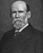
William Henry Mouzon, Jr. was an American cartographer and civil engineer.
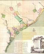
Henry Mouzon, Jr. was the grandson of a Huguenot immigrant and was sent to France at the age of eight, where he was trained as a civil engineer and surveyor. In 1771 he and Ephraim Mitchell were sent to survey the boundaries of South Carolina. As a result, a map was created and published in 1775 that included both North and South Carolina with corrections to previous maps.
This map was entitled "An Accurate Map of North and South Carolina with their Indian Boundaries," and clearly showed all the mountains, rivers, swamps, marshes, bogs, bays, creeks, harbors, sandbanks and shoals on the coasts, and gave the names of the land owners. American, British, and French troops used this map during the American Revolution. A copy of this map, owned by George Washington, is now in the library of the American Geographical Society.
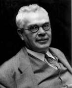

Francis Gladheim Pease was an American astronomer and optical instrument maker.
Pease graduated from the Armor Institute of Technology in Chicago, worked as an optician and observer at Yerkes Observatory, and from 1904 also made optical instruments at Mount Wilson Observatory, where he worked for 34 years. Pease designed a 100-inch telescope as well as a 50-foot interferometric telescope, with which he made direct measurements of the diameters of stars. He also participated in the development of the Hale telescope.
In 1928 he found the first planetary nebula in a globular cluster (M15), now cataloged as Pease. Francis Gladheim Pease also took very high quality photographs of the surface of the Moon, and a crater on this Earth satellite is named in his honor.


John Ross was an American military cartographer and surveyor.
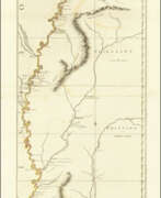
Lieutenant John Ross served as a surveyor in the 34th Regiment of the British Army. After the Treaty of Paris in 1763, a British expedition was sent into Illinois Territory to demand the surrender of Fort de Chartres, the last outpost under French control in the area. John Ross traveled with this expedition, surveyed the lower river to the mouth of the Mississippi River, and created a unique map. It was titled "The Course of the Mississippi River from Balise to Fort Chartres; taken on an Expedition to Illinois" and published in London in 1775.
Lieutenant Ross's large-scale map of the Mississippi River is one of the few large format maps of the Mississippi published in the 18th century. Ross's map was the first official English survey of the Lower Mississippi and one of the most historically significant American maps. It delineated British territorial acquisitions after the French and Indian War and then established the future western boundary of the new United States. The map opened the territory to settlement from the east and defined the western boundaries of the American colonies.