Engineers 18th century

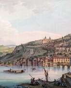

Jean-François Albanis Beaumont was a French landscape painter, engineer, traveler and geographer.
He studied engineering in Paris and worked on architectural structures at Chambérly. Beaumont later accompanied the Duke of Gloucester, William Frederick of Hanover on a grand tour of Germany, Italy, France, and Switzerland, making notes and detailed pictorial sketches of views along the way. In 1800 he published the illustrated books Journey to the Lepontine Alps from France to Italy and Description of the Grecian and Cottian Alps (1802 and 1806).

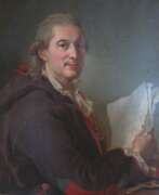
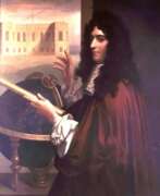
Marin Carburi of Ceffalonie was a Greek military engineer from Kefalonia.
Carburi studied mathematics at the University of Bologna, but later had to flee and became an officer in Catherine the Great's Russian army. He became famous for being able to transport the infamous Grom Stone from the Gulf of Finland to St. Petersburg to serve as a pedestal for the equestrian statue of Peter the Great.
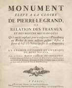
The history of this engineering feat is quite remarkable. The French architect Falcone, who was commissioned to create a monument to Peter the Great, decided that traditional pedestals for equestrian statues were too banal for this project, and decided that only a massive rock would do. After a long search for a suitable rock, a peasant informed the commission created for this purpose that he had found a huge rock measuring forty by twenty-seven by twenty-one feet in a swamp near the Gulf of Finland. After the majority of engineers recognized its movement impossible, Catherine II commissioned Carburi to do it, with which he brilliantly coped. In fact, the military engineer became the inventor of ball bearings, creating a giant sled based on them. He wrote a detailed treatise about it, published in Paris in 1777.
Back home in Kefalonia, Carburi took up farming, but in 1782 he was murdered by his workers.


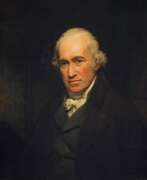
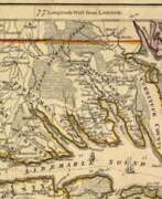
Johann Wilhelm Gerhard von Brahm, also known as John William Gerard de Brahm, was a German cartographer, military engineer, and surveyor who worked for Great Britain to develop the lands of the New World.
His father was court musician to the Elector of Trier and gave his son an excellent early education. After a successful career as a military engineer in the Bavarian army, de Brahm traveled to Georgia in 1751 at the head of a group of German emigrants. There he displayed his talents as a surveyor and engineer, worked as a cartographer, and was commissioned by South Carolina Governor James Glen to design and build a system of fortifications for Charleston.
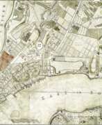
In 1755 de Brahm was appointed inspector general of lands for South Carolina and soon for the entire New World. He settled in St. Augustine, where he spent the next six years researching and preparing maps. His major works, "Map of South Carolina" and "Map of South Carolina and Part of Georgia," provide detailed topography and even describe underwater features. And his "Report of a General Survey of the Southern District of North America" records every detail from tide times to tips on tilling the soil. De Brahm's book The Atlantic Pilot, an instruction manual for sailing in Florida, was published in London and included the first published map of the Gulf Stream.

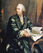

Leonhard Euler was the greatest mathematician of the 18th century and history in general.
Euler brilliantly graduated from the University of Basel and entered the St. Petersburg Academy of Sciences, then began to work at the Berlin Academy, and later to lead it. In 1766, the scientist received an invitation from the Russian Empress Catherine II and again came to St. Petersburg to continue his scientific work.
Here he published about 470 works in a wide variety of fields. One of them is a large-scale work "Mechanics" - an in-depth study of this science, including celestial mechanics. Euler by that time was practically blind, but continued to be actively engaged in science, in the records he was helped by his son Johann Albrecht and stenographers. Leonhard Euler made many fundamental discoveries that brought great benefit to mankind.
His massive contribution to the development of mathematics, mechanics, physics and astronomy cannot be overestimated, and his knowledge in the most diverse branches of science is admirable. During his lifetime, he published more than 850 works that contain in-depth studies of botany, chemistry, medicine, ancient languages, and music. Euler held membership in many academies of science around the world.


Samuel Johannes Holland was a Dutch-born British military engineer, surveyor and cartographer, and the first Inspector General of British North America.
He began his military career in 1745 in the Dutch artillery, moving to England in 1754 and becoming a lieutenant in the Royal American Army. In early 1756 Holland traveled with the British army to North America, where he created the first maps of New York State, worked as a military engineer, surveyed Louisbourg, Halifax, and Fort Fredericton, and participated in the siege of Quebec in 1759.
In 1764 Holland was appointed inspector general of the Northern District of North America and was appointed to the Quebec Council. From 1764 to 1767, he surveyed Prince Edward Island, the Madeleine Islands, and Cape Breton. He then mapped the northeast coast for the British army and helped negotiate provincial and state boundaries in the northeast. In 1779, Samuel Holland was appointed a member of the Legislative Council of Quebec and continued to serve as Inspector General for the rest of his life.


Arsène Lacarrière Latour, full name Géraud Calixte Jean Baptiste Arsène Lacarrière Latour, was a French-born American engineer and military officer, architect and surveyor, and writer.
He studied architecture and engineering at the Académie des Beaux-Arts in Paris and served briefly in the French Army Corps of Engineers. In 1805 Latour came to New York, where he worked first as a merchant, then as an architect and surveyor, and opened an architectural firm in New Orleans. In 1812. Latour became a U.S. citizen.
In 1814. Latour became Andrew Jackson's military engineer and made an important contribution to the American victory at the Battle of New Orleans. After the war ended, Latour published a book, Historical Memoirs of the War in West Florida and Louisiana, 1814-1815, which is still valued for its eye-witness view of the war.
In 1816. Latour traveled with Jean Lafitte on an expedition to survey and map the Southwest as an agent for Spain. From 1818 to 1834 he worked as an architect in Havana. His manuscripts include an extensive report describing Havana's thriving economy in 1815-1821, local agricultural production (sugar cane, coffee, tobacco), trade with Europe, the United States, and the colonies of South America; statistics; and a section on the city's possible future expansion and growth. Latour subsequently returned to France, where he died.
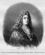

Sébastien Leclerc was a French graphic artist of the second half of the seventeenth and early eighteenth centuries. He is known as a brilliant master of engraving and woodcuts, as well as an art theorist and military engineer.
Leclerc created more than 3,400 engravings during his career, most of them in the religious genre. He was also famous for his illustrations of French literary novels and scientific treatises on art theory, architecture, and geometry.
The artist's son Sebastien Leclerc Jr. and grandson Jacques-Sebastien Leclerc became famous as painters.


John Montresor was a British military engineer and cartographer who worked in North America.
His father was a military engineer and his youth was spent in British Gibraltar. Montresor studied in London, and in 1754 accompanied his father to North America when he was appointed chief engineer to Major General Edward Braddock's troops. John participated in various expeditions, delivered dispatches, and witnessed the sieges of Louisbourg and Quebec. During his service, he also did the necessary research and prepared maps of Acadia, the St. Lawrence River, and his route along the Kennebec River.
One of John Montresor's major accomplishments is the strategic map of the Hudson River, one of the most detailed maps of the New York City area during the American Revolution, first published in 1775. The map extends from Lake Champlain down the Hudson to Long Island, with insets of Lake Champlain and the White Hills in the upper Connecticut Valley.
John Montresor was promoted to captain in 1776, returned to England in 1779, and retired from the army. He died in prison 20 years later, accused of excessive spending while in the service.

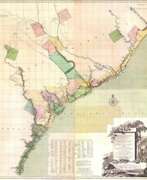
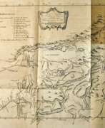
William Henry Mouzon, Jr. was an American cartographer and civil engineer.
Henry Mouzon, Jr. was the grandson of a Huguenot immigrant and was sent to France at the age of eight, where he was trained as a civil engineer and surveyor. In 1771 he and Ephraim Mitchell were sent to survey the boundaries of South Carolina. As a result, a map was created and published in 1775 that included both North and South Carolina with corrections to previous maps.
This map was entitled "An Accurate Map of North and South Carolina with their Indian Boundaries," and clearly showed all the mountains, rivers, swamps, marshes, bogs, bays, creeks, harbors, sandbanks and shoals on the coasts, and gave the names of the land owners. American, British, and French troops used this map during the American Revolution. A copy of this map, owned by George Washington, is now in the library of the American Geographical Society.


John Ross was an American military cartographer and surveyor.
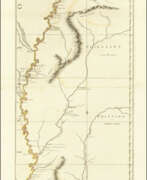
Lieutenant John Ross served as a surveyor in the 34th Regiment of the British Army. After the Treaty of Paris in 1763, a British expedition was sent into Illinois Territory to demand the surrender of Fort de Chartres, the last outpost under French control in the area. John Ross traveled with this expedition, surveyed the lower river to the mouth of the Mississippi River, and created a unique map. It was titled "The Course of the Mississippi River from Balise to Fort Chartres; taken on an Expedition to Illinois" and published in London in 1775.
Lieutenant Ross's large-scale map of the Mississippi River is one of the few large format maps of the Mississippi published in the 18th century. Ross's map was the first official English survey of the Lower Mississippi and one of the most historically significant American maps. It delineated British territorial acquisitions after the French and Indian War and then established the future western boundary of the new United States. The map opened the territory to settlement from the east and defined the western boundaries of the American colonies.

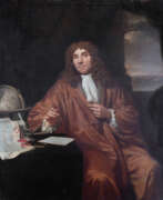

Antonie Philips van Leeuwenhoek was a Dutch microbiologist and microscopist in the Golden Age of Dutch science and technology. A largely self-taught man in science, he is commonly known as "the Father of Microbiology", and one of the first microscopists and microbiologists. Van Leeuwenhoek is best known for his pioneering work in microscopy and for his contributions toward the establishment of microbiology as a scientific discipline.