ID 411437
Lot 30 | Boston under Siege
Valeur estimée
$ 80 000 – 120 000
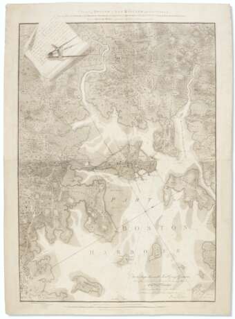
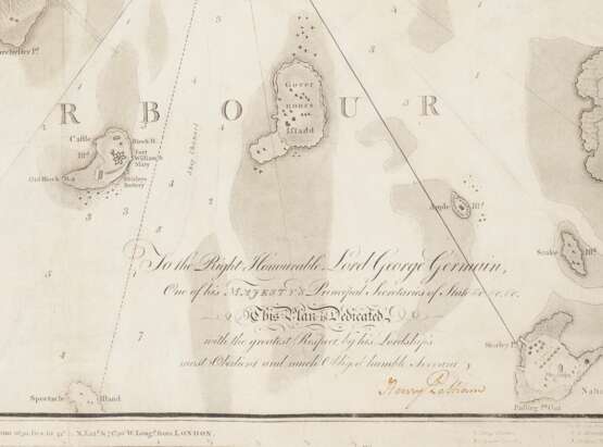
Henry Pelham’s magnificent map of Boston under siege commissioned by British intelligence—the first complete copy to appear at auction in 25 years. Best known for conceiving the Boston Massacre image made popular by Paul Revere’s 1770 engraving, by 1775 Pelham had become a confirmed Loyalist. During the nearly yearlong siege of Boston, Pelham reconnoitered the landscape armed with a pass from James Urquart, the town major of Boston, which he reproduces at the upper left corner with a cleverly-placed image of a compass as a paperweight. On 28 August 1775, Urquart had given Pelham free passage "to take a plan of the town's of Boston & Charlestown and of the rebel works round those places." Writing to his half-brother John Singleton Copley in early 1776, he reported that the survey, which extended four miles in all directions from the center of Boston, was nearly complete, and described the desolate countryside that he enountered: "fences pull'd down, houses removed, Woods grub[b]ed up, Fields cut into trenches and molded into Ramparts … Nor has Boston been free from the Effects of War. An hundred places you might be brought to and not know where you were. I doubt if you would know the town at all" (Pelham to Copley, 27 Jan. 1776, in Letters & Papers of John Singleton Copley and Henry Pelham, 1739-1776, 1914, p. 366). In March 1776, the Continental Army brought fresh cannon from Fort Ticonderoga and positioned them at Dorchester Heights, directly threatening Boston with bombardment and forcing the British to evacuate the town. Interestingly, Pelham shows a fortification at Foster's Hill denoting them as "New Works 1776." Pelham would leave with the departing British forces, along with much of the Loyalist population of the town, destined for Nova Scotia. Pelham continued on to London and the Copley family, where he would have this survey published a year later employing the newly-fashionable aquatint method.
Rare. According to Deák, there are fewer than a dozen recorded impressions of this map: “Topographically accurate and handsomely executed … It is an unusually fine and comprehensive survey and, as such, constitutes an important document of the Revolutionary period.” Picturing America, 147; John W. Reps, “Boston and Bostonians,” in Boston Prints and Printmakers 1670-1775, fig. 26; Nebenzahl 20. The last complete copy to appear at auction was at Sotheby's, New York, 13 December 1995, lot 299.
Engraved map on two joined sheets, 1076 x 780mm overall (light rubbing from old creases, resized, edges reinforced on verso repairing some small holes and an area of infill affecting two letters in title).
| Adresse de l'enchère |
CHRISTIE'S 8 King Street, St. James's SW1Y 6QT London Royaume-Uni | |
|---|---|---|
| Aperçu |
| |
| Téléphone | +44 (0)20 7839 9060 | |
| Commission | see on Website | |
| Conditions d'utilisation | Conditions d'utilisation |


