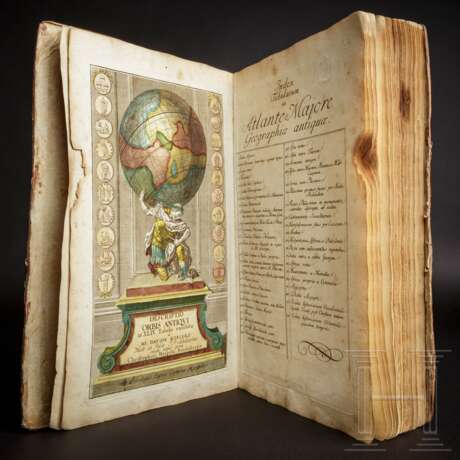
"Descriptio Orbis Antiqui in XLIV. Tabulis exhibita" a Io. Davide Koelero"; kolorierter Atlas, Christoph Weigel, Nürnberg, um 1720
21.06.2021 10:00UTC +01:00
Classic
Vendu
1300EUR € 1 300
| Auctioneer | Hermann Historica |
|---|---|
| Lieu de l'événement | Allemagne, Grasbrunn / München |
| Commission | 25 % |
Archive
La vente aux enchères est terminée. Vous ne pouvez plus enchérir.

ID 579474
Lot 6004 | "Descriptio Orbis Antiqui in XLIV. Tabulis exhibita" a Io. Davide Koelero"; kolorierter Atlas, Christoph Weigel, Nürnberg, um 1720
Valeur estimée
€ 500
Dieser Atlas enthält 40 (statt 44) altkolorierte Karten der Alten Welt. Folio (28x38,5 cm), gedruckt bei Christoph Weigel in Nürnberg. Der Atlas zeigt die westliche Welt, mit Karten von Eurasien mit Afrika, Europa, Hispanien, Gallien, der Britischen Inseln, Germanien, Italien, Palästina, Ägypten, Mesopotamien, etc. Viele Karten mit Münzdarstellungen. Koloriertes Titelkupfer, verso Besitzvermerk in Tinte ("Ludwig Grimme, cand. phil., November 1879"), Inhaltsverzeichnis. 40 Karten in schönem Altkolorit (es fehlen die Nummern 9, 15, 23, 24). Am Titel, Index, den ersten beiden Karten sowie den Karten 27 bis 37 Randschaden, ebenso Braunfleck rechts oben von Karten 19 bis 27. Die Schäden jeweils im weißen Rand, ohne Bildverlust. Längsknick in Karte 14 (Italien). Hinterlegter Einriss auf Karte 39 (Mauretania et Numidia) ohne Papierverlust, nicht bis in die Karte reichend. Die Karten selbst nur gering gebräunt und fleckig. Halbledereinband, der Rücken restauriert, teilweise eingerissen, rundum berieben und bestoßen.
Der Atlas insgesamt in einem brauchbaren Zustand.
Zustand: III
"Descriptio Orbis Antiqui in XLIV. Tabulis" by David Koehler; hand-coloured atlas, Nuremberg, circa 1720
Folio, engraved title and index, 40 (of 44) hand-coloured engraved maps of the ancient world. The atlas shows the western world, with maps from Eurasia/Africa, Europe, Hispania, Gallia, the British Isles, Germania, Italia, Palestine, Egypt, Mesopotamia, etc. Many maps decorated with numismatic elements.
Coloured title, on the reverse a handwritten property note ("Ludwig Grimme, cand. phil., November 1879"), index. 40 double-page maps (# 9, 15, 23, 24 missing), original coloring. Title, Index, the first two maps and maps 27 to 37 with damages to the white margin, a brown spot in the top corners of maps 19 to 27. The damages limited to the white margins. Map 14 (Italy) bent down the middle. A 4 cm long tear doubled-up with a paper strip on map 39 (Mauretania et Numidia), no loss to paper, not touching the map. Occasional, very light browning and foxing to the maps. The fly-leaves soiled.
Contemporary half-vellum over marbled boards with gilt stamped back (repaired, with a 30mm crack front bottom), worn at the corners and around the edges.
Overall a still acceptable copy of this skilfully elaborated atlas.
Cf. Phillips, Atlases, 30.
Condition: III
| Catégorie maison de vente aux enchères: | Littérature |
|---|
| Catégorie maison de vente aux enchères: | Littérature |
|---|
| Adresse de l'enchère |
Hermann Historica Bretonischer Ring 3 85630 Grasbrunn / München Allemagne | ||||||||||||||
|---|---|---|---|---|---|---|---|---|---|---|---|---|---|---|---|
| Aperçu |
| ||||||||||||||
| Téléphone | +49 (0)89 5472 649 0 | ||||||||||||||
| Fax | +49 (0)89 5472 64999 | ||||||||||||||
| Commission | 25 % | ||||||||||||||
| Conditions d'utilisation | Conditions d'utilisation | ||||||||||||||
| Heures d'ouverture | Heures d'ouverture
|


