PORTOLAN CHART OF THE MEDITERRANEAN, NORTHERN EUROPE, AND THE NORTHWEST ATLANTIC OCEAN
10.09.2024 00:00UTC +00:00
Classic
Vendu
302400USD $ 302 400
| Auctioneer | CHRISTIE'S |
|---|---|
| Lieu de l'événement | Royaume-Uni, London |
| Commission | see on Website% |
Archive
La vente aux enchères est terminée. Vous ne pouvez plus enchérir.

ID 1279133
Lot 4 | PORTOLAN CHART OF THE MEDITERRANEAN, NORTHERN EUROPE, AND THE NORTHWEST ATLANTIC OCEAN
Valeur estimée
$ 70 000 – 100 000
[PROBABLY CIVITAVECCHIA OR NAPLES, LAST QUARTER OF THE 16TH CENTURY]
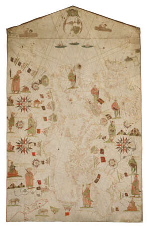
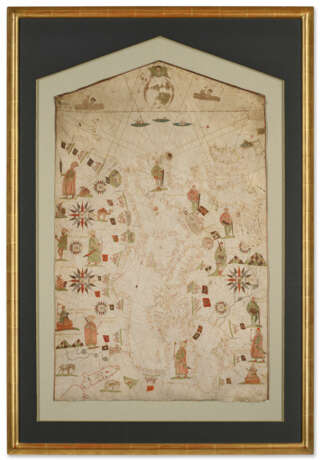
Manuscript portolan chart, gold, ink and colors on a single vellum sheet. The chart extending from Azores to the Holy Land, from Scandinavia and Iceland to the Nile, coastlines in gold, islands in green, red, gold and silver, rivers and lakes in sepia and grey, over 1,200 coastal place-names in red and sepia in a small neat gothic rotunda, 22 detailed town vignettes, heightened in gold and surmounted by flags, the principal kingdoms of Europe and North Africa decorated with 15 elaborate figures of monarchs, North Africa with additional decoration in the form of camels, elephants and mountain ranges, 8 large and small compass roses each with gilt fleur-de-lys north points, the seas of the Atlantic decorated with 2 vignettes of spouting whales, 2 ships and a serpent-like sea monster, the neck of the chart with God the father looking down on a schematic circular map of the world, the whole chart divided by rhumb-lines extending from the compass roses, sepia and red-ruled borders.
A richly decorated and highly accomplished manuscript portolan chart of Europe, centered on the Mediterranean, but extending from Iceland to the Red Sea, and from the Azores to Crimea.
Hand drawn by expert cartographers with great knowledge of the sea, portolan sea charts sprang unheralded into being in the 13th century—no precursors can now be traced—and were a primary maritime navigational aid until the 18th century, when large-format printed sea charts became feasible. Portolan charts do not utilize lines of latitude and longitude, but instead are crisscrossed by loxodromes and rhumb-lines representing the points of the compass. Coastal forms are drawn according to the navigators’ reports of appearance, direction and estimated distance between the points. Portolan charts are generally devoid of inland information, but the coastlines are filled with place names written perpendicular to the coastline so as not to obscure the coastal detail.
The blank inland areas presented opportunities for the enterprising portolan cartographer to decorate charts for a solely land-based market interested in seeking ornamental status symbols; it may be assumed that only a fraction of portolan charts produced have survived to the present day, and the majority of those lost were unadorned with decoration, rather serving as utilitarian navigational aids, and thus subject to wear and tear.
Since this chart was sold at Christie’s in 1995, more research has been published, and it now seems unlikely that it was made in either Levanto or Genoa as was then suggested. The chart is indistinctly signed near its neck, but does bear the name Jacopo Scotti. Scotti (aka Giacomo Scotto or Jacobus Scotus) was a Ligurian born in Levanto. He lived until 1592 at Civitavecchia, where in 1589 he produced a chart (Biblioteca Nazionale Marciana, Venice) and an atlas of 9 charts (Biblioteca Capitolare, Verona). One chart (the whereabouts of which are currently unknown) has been ascribed to him as early as 1578. In 1592 Scotti moved to Naples, and produced two atlases there, both comprising 7 charts: one in 1592 (State Library of NSW, Sydney), and another in 1593 (Biblioteca dell'Archiginnasio, Bologna).
Campbell has noted how the decorative elements of portolan charts evolved from quite an early point in their development into two main styles: the ‘Catalan’ and the ‘Italian’. The ‘Catalan style’ is luxurious with a host of decorative rivers, mountains, cities and other features crammed into the blank inland areas. This style began in the 15th century, and was particularly adopted by chartmakers based in southern Spain, Majorca, Marseilles and Sicily. By contrast, the ‘Italian style’ is far more restrained, almost completely devoid of anything that is not functional.
By the 16th century, centers of portolan chart production had proliferated to such an extent that it no longer becomes sensible to speak of such stylistic trends based on geography, but a more valid contrast might be made between functional versus decorative charts and atlases made for presentation (or ‘luxurious charts’ as Ramon Pujades has called them). Scotti certainly drew charts in both a highly decorative and a more restrained style, without a discernible pattern according to place or date of production.
This particular chart is indeed ‘luxurious,’ incorporating numerous decorative figures, townscapes surmounted by flags and elaborate 16-point compass roses. Both Scotti’s 1589 chart and the present lot bear many stylistic similarities, including an oversize birds-eye view of the city of Genoa—larger than that of Venice—which is a reference to the cartographer’s native regional capital literally writ large (Scotti himself did not operate in Genoa because the Maggiolo family held that state’s privilege and monopoly of map production).
However, whereas Scotti’s 1589 Civitavecchia chart displays St Andrew in the neck of the chart, a conventional religious device, the present map is highly unusual—perhaps unique—in the use of a circular world map to decorate the neck. This world map is extremely close in style to the larger world map Scotti drew in his 1592 Neapolitan-produced atlas (now in the Mitchell Library, N.S.W.), with a bulbous central America, very large Arctic and Antarctic landmasses, distinctly separate Sri Lanka and a central Asian Caspian Sea. Yet this 1592 atlas is of a very much more restrained style, without decoration in the inland areas.
Scotti also uses two different styles to delineate the border between England and Scotland: the present chart depicts the island of Great Britain split into two with a canal of parallel lines, whereas both Scotti’s 1589 chart in ‘Catalan style’ and his 1592 atlas in ‘Italian style’ adopt a mountain range to separate the two kingdoms.
Chet van Duzer has suggested that some portolan cartographers, including Vesconte Maggiolo (c.1475-1551) of Genoa, produced such charts using hand-stamps for the decorations: the hand-stamps generated the outlines, which were then painted in colors. This provided efficiencies in time and money, as specialized artists did not need to be hired to draw various decorations, and it is possible to discern over a sequence of charts the reuse of stamps depicting the same city, ship, or monarch. Van Duzer has suggested the possibility that Scotti has also employed such stamps on this chart, most notably on the images of the monarchs and sovereigns, whereby they have a stiff, wooden quality to them, rather than the expected fluidity of hand-drawn images; he suggests that the monarchs of France, Germany, Hungary and Moscow were all made from the same stamp. It is also possible that some of the animals were also made with stamps, although Van Duzer notes that paint loss – particularly of the light green – makes it difficult to distinguish between stamped-and-painted figures and those figures wholly hand-drawn. Nonetheless, the hitherto overlooked use of print technology in the production of what are ostensibly manuscript charts invites many opportunities for exciting new research.
Christie’s would like to thank Richard Pflederer and Chet van Duzer for their help in cataloging this lot.
Pflederer Census of Portolan Charts and Atlases, S019.
38 3/16 x 23 5/8 in. (97 x 60 cm.)
Provenance
Anonymous sale; Christie’s, 24 May 1995, lot 80.
The Map House.
Acquired from the above by the late owner.
Literature
M.C. Andrews. ‘The boundary between Scotland and England in the Portolan Charts’ in Proceedings of the Society of Antiquaries of Scotland, (1926) 60, 36–66.
C. Astengo. ‘The Renaissance Chart Tradition in the Mediterranean’ in The History of Cartography, Volume 3, Part 1 (2007), pp.174-262.
T. Campbell. ‘Portolan Charts from the Late Thirteenth Century to 1500’ in The History of Cartography, Volume 1 (1987), pp.371-463.
Chet Van Duzer. ‘Print in a Manuscript Realm: The Use of Hand-Stamps in the Decoration of Renaissance Nautical Charts,’ delivered 1 August 2019, in the Rare Book and Special Collections Division, Library of Congress, Washington DC, https://www.youtube.com/watch?v=gs58IA5IIWA
| Lieu d'origine: | Italie, Europe |
|---|---|
| Catégorie maison de vente aux enchères: | Cartes et Atlas, Médecine et sciences, Livres et manuscrits |
| Lieu d'origine: | Italie, Europe |
|---|---|
| Catégorie maison de vente aux enchères: | Cartes et Atlas, Médecine et sciences, Livres et manuscrits |
| Adresse de l'enchère |
CHRISTIE'S 8 King Street, St. James's SW1Y 6QT London Royaume-Uni | |
|---|---|---|
| Aperçu |
| |
| Téléphone | +44 (0)20 7839 9060 | |
| Commission | see on Website | |
| Conditions d'utilisation | Conditions d'utilisation |


