ID 627584
Lot 94 | The "Blue Map" of the World
Valeur estimée
$ 50 000 – 80 000
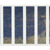
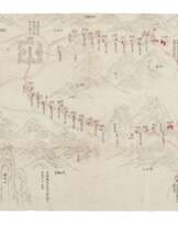
Extremely rare example of the famous "blue map" of the world, uniquely printed in "yin" (relief) and "yang" (intaglio) woodblock engraving. Showing China at the height of the Qing empire. Only a handful of copies are recorded in institutional collections.
According to the text on panel one (reading from right to left), the map was based on another drawn by Huang Qianren (1694-1771) from Yuyao. This original map was probably executed in 1767, although no example of it now survives. However, a manuscript copy of the map was produced in 1800 which now resides in the National Library of China. A revised and enlarged woodblock-printed version was produced probably sometime around 1811: and exists in two versions, one in black and white and the other in blue, as here. The title of the map is as much a political statement, as it is a geographical record, celebrating the "unified status of all Chinese borders" (Pegg).
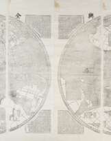
Greater than its propagandistic nature, the map also had a useful purpose: to aid in the administration of the empire. Its surface swarms with numerous administrative details and named symbols: squares capped by small rectangles = provincial capitals (sheng); squares = prefectures (fu); squares capped with triangles = independent district magistrates (zhilizhou); vertical rectangles = departments (zhou); diamonds = sub-prefectures (ting); circles = counties (xian); small buildings = frontier passes (guan); triangles = local headmen or western tribute states (tusi); dotted lines delineate provincial borders. The physical geography is represented with mountains, deserts, rivers and coast lines all depicted, as is the mid-Qing era Great Wall with its checkpoints. The map focuses on two rivers, the Yellow and the Yangtze. The origin of the Yellow River is drawn correctly; however, the map still shows Minjiang River as the source of the Yangtze River, which repeats the old legend and is not correct.
"[This] 'complete' map minimizes the European notion of a map of the world, its centralized and marginalizing construct confirming the Qing/Chinese notion of the Central Kingdom" (Pegg). Although Russia, India, Thailand, Vietnam, Japan and Korea are clearly defined (especially the latter which has a large textual commentary, indicating its status as the chief vassal state), there are no international borders: "The intentionally vague geopolitical lines of the [empire’s] frontiers and beyond clearly indicate the Qing’s perception of the world around them ... All foreign entities simply inhabited the fringes of the empire" (Pegg). To the upper left of the map lie both the Mediterranean ("Small Western Ocean"), and Atlantic ("Great Western Ocean"), with both the Netherlands and Great Britain shown as islands. "Two prominent visual features of this map do align well with the claims of China's greatness that maps of this genre tend to assert. The massive scale of this eight-part map, which fills the viewer's field of view, lends grandiosity to its subject. Moreover, the work's palette dramatically imbues its subject with antique culture, for the deep blue and green colors recall the opaque mineral pigments of the venerable blue-and-green style of painting (Smith).
The author of the original map, Huang Qianren, was the grandson of Confucianist scholar and cartographer Huang Zongyi (1610-1695), who produced Yudi Zongtu (Complete Map of China), a significant source of Huang Qianren’s later map. We have been able to trace the following examples recorded in institutions – China: National Library, Beijing; Beijing University Library; Shandan Museum in Gansu Province; USA: Library of Congress, Washington DC; Maclean Collection, Chicago; Harvard-Yanching Library; Japan: Kobe City Museum; Waseda University Library. References: Reading Imperial Cartography: Ming-Qing Historical Maps in the Library of Congress (2013), pp. 88-89; Richard Pegg, Cartographic Traditions in East Asian Maps (2014) pp.8-9, 18-26; Richard Smith, Chinese Maps: Images of ‘All Under Heaven’ (1996).
Large woodblock world map, printed on paper, composed of 8 separate panels, each individually matted. First and last panels are approximately 1310 x 270 mm and the others are approximately 1310 x 290 mm for an overall size of 1310 x 2280 mm or about 4.25 by 7.5 feet. Administrative divisions printed in relief, the mountains, rivers and islands printed intaglio; the Gobi Desert depicted in a series of dots which are finished in gradient red by hand. Some areas of loss attributed to printing process to bottom left-hand side of panel 3 and small area of sea in panel 1, these features also appearing in another two copies of the map, one also produced in c.1811 sold at Christie’s 12 Dec, 2018, lot 191, and the other produced in 1823 sold at Sotheby’s 9 May 2017, lot 119. (First and last panels discolored, uneven fading to the lower portion of each panel, light surface abrasions; panel 1 with an approx. 90 x 75 mm area of loss to the upper part of the long inscription, an approx. 110 mm horizontal crack below, repaired tears and dampstains throughout; panel 4 and 7 with dampstains at the lowermost portions; panel 5 and 8 with a few wormholes around the area depicting the sea; panel 8 with tears and cracks throughout the surface, the longest one approx. 230 mm, stains around the lower margin and upper left corner.)
Exhibited: “The World on Paper: From Square to Sphericity,” Hong Kong Maritime Museum, December 2019 to March 2020.
Please note that this lot is subject to an import tariff. If the buyer instructs Christie’s to arrange shipping of the lot to a foreign address, the buyer will not be required to pay the import tariff. If the buyer instructs Christie’s to arrange shipping of the lot to a domestic address, if the buyer collects the property in person, or if the buyer arranges their own shipping (whether domestically or internationally), the buyer will be required to pay the import tariff. Please contact Post Sale Services on +1 212 636 2650 prior to bidding for more information.
| Artiste: | William Shakespeare (1564 - 1616) |
|---|---|
| Technique appliquée: | Crayon |
| Artiste: | William Shakespeare (1564 - 1616) |
|---|---|
| Technique appliquée: | Crayon |
| Adresse de l'enchère |
CHRISTIE'S 8 King Street, St. James's SW1Y 6QT London Royaume-Uni | |
|---|---|---|
| Aperçu |
| |
| Téléphone | +44 (0)20 7839 9060 | |
| Commission | see on Website | |
| Conditions d'utilisation | Conditions d'utilisation |

