


ID 1119188
Lot 8 | Les Voyages de la Nouvelle France occidentale ... Iusques en l'an 1629
Valeur estimée
$ 150 000 – 250 000
Samuel de Champlain, 1632
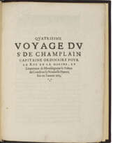
CHAMPLAIN, Samuel de (1567-1635). Les Voyages de la Nouvelle France occidentale, dicte Canada faits par le Sr Champlain Xainctongeois, Capitaine pour le Roy en la Marine du Ponant, & toutes les Descouvertes qu'il a faites en ce paos depuis l'an 1603. Iusques en l'an 1629. Paris: Claude Collet, 1632.
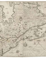
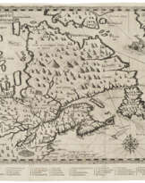
First edition of Champlain’s last work, the first collected edition of his voyages and including discoveries through 1629. With the rare and important large map, arguably “the first to depict the existence of the entire Great Lakes network” (Burden).
This work “contains a collective narrative embodying a review of all preceding French expeditions to the New World, followed by and interwoven with Champlain’s own voyages to Canada” (Church). It also contains the first accurate accounts of the Native inhabitants of what is now the central part of New York State. Following an abridgement of the 1613 edition (see preceding lot), this work additionally describes Champlain’s seventh and ninth voyages (the eighth is mentioned only incidentally as unimportant) and contains a History of Canada, a Treatise on Navigation; and the Doctrine Chrestienne, du R. P. Ledesme and l’Oraison Dominicale” (ibid). These latter works translate scripture into the Huron language.
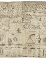
Second issue as usual, with the setting of p.27 which removes the offensive passage regarding Cardinal Richelieu. The book was dedicated to Richelieu and the cancelled leaves replace a five-line passage which was supposed to be held objectionable by him, namely that great princes might know well how to conduct the government of a kingdom, and yet not know how to sail a ship. The map is also second state, with a more accurate orientation of the major lake on Cape Breton island.
The important map, Champlain’s final work, covers the same territory as that of circa 1616, but with greater detail, especially improving on the Great Lakes. “Lac St Louis is Lake Ontario, leading up to number ‘90’, marking ‘a fall of water at the end of the Falls of St. Louis, very high, where many kinds of fish are stunned in descending’. Above La nation neutre appears a rudimentary Lake Erie followed by a more recognizable Mer douce, Lake Huron, the ‘freshwater sea’. Grand Lac, or Lake Superior, which Champlain never actually saw, is here depicted for the first time in a recognisable form on a map. Reports of its existence probably came to him through Etienne Brûlé, one of the first coureurs de bois ...
An illustration of a church serves to indicate the Dutch presence in the region, and is considered the first delineation of present-day New York City on a printed map” (Burden). Notably, there is no reference to the English in New England—perhaps Champlain thought his map would better encourage French settlement if he avoided acknowledging the British in the area, even though this map does cover an area as far south as Virginia. The Hudson River is here called "Riuere des trettes" and Long Island "Isle de l'Ascension." Alden & Landis 632⁄22; Burden 237; Church 420; Harrisse, Nouvelle France 51; Lande 118; Pilling Algonquian pp. 79-81; Schwartz & Ehrenberg, pl. 48; Streeter sale 3621.
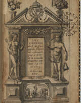
Three parts in one, quarto (224 x 164mm). Large engraved folding map, "Carte de la nouvelle france" (map with some tiny losses at fold intersections, on a later stub, old patch on verso repairing a stub tear, small stain near patch); 6 engraved illustrations in text, two of which are full-page; woodcut map on 3C4 and woodcut illustrations on 3G2v. With original blanks 22Q4 and 3G4. (Toning to most page margins and at ends, blank marginal tears from O1, Q1 and 22F1, closed tear just into text on 4B3, a few leaves with ragged outer margins.) Early limp vellum, spine lettered in manuscript (soiled, ties lacking, spine unevenly darkened).
| Artiste: | Samuel de Champlain (1567 - 1635) |
|---|---|
| Lieu d'origine: | Europe de l'Ouest, France, Europe |
| Catégorie maison de vente aux enchères: | Livres imprimés |
| Artiste: | Samuel de Champlain (1567 - 1635) |
|---|---|
| Lieu d'origine: | Europe de l'Ouest, France, Europe |
| Catégorie maison de vente aux enchères: | Livres imprimés |
| Adresse de l'enchère |
CHRISTIE'S 20 Rockefeller Plaza 10020 New York Etats-Unis | ||||||||||||||
|---|---|---|---|---|---|---|---|---|---|---|---|---|---|---|---|
| Aperçu |
| ||||||||||||||
| Téléphone | +1 212 636 2000 | ||||||||||||||
| Fax | +1 212 636 4930 | ||||||||||||||
| Conditions d'utilisation | Conditions d'utilisation | ||||||||||||||
| transport |
Service postal Service de messagerie ramassage par vous-même | ||||||||||||||
| Modes de paiement |
Virement bancaire | ||||||||||||||
| Heures d'ouverture | Heures d'ouverture
|
Termes connexes
Déposer un ordre
Déposer un ordre par téléphone Ordre

| Numéro de lot | 8 |
|---|---|
| Maison de vente aux enchères | CHRISTIE'S |
| Date de l'enchère | 17.01.2024 |
Votre ordre: $ 150 000
Téléphones pour la communication:
+34827387, +232346832
C'est votre offre maximale qui est transmise à la maison des ventes aux enchères. Si l'offre maximale est plus en haut que le prix limite de l'article, le commissaire-priseur offrira pour vous jusqu'à la hauteur de l'offre maximale.
C'est votre enchère maximale, qui est transmise à la maison de vente aux enchères. Si l'enchère maximale est plus haut que le prix minimal de l'article, le commissaire-priseur offrira pour vous jusqu'à la hauteur de l'enchère maximale.
| Numéro de lot | 8 |
|---|---|
| Maison de vente aux enchères | CHRISTIE'S |
| Date de l'enchère | 17.01.2024 |
Erreur ordre
| Numéro de lot | 8 |
|---|---|
| Maison de vente aux enchères | CHRISTIE'S |
| Date de l'enchère | 17.01.2024 |
Вы уже сделали ставку в € 40 000 и ставка принята аукционным домом. Если вы хотите ее уменьшить, то обратитесь напрямую в администрацию аукционного дома.
Erreur ordre
| Numéro de lot | 8 |
|---|---|
| Maison de vente aux enchères | CHRISTIE'S |
| Date de l'enchère | 17.01.2024 |
Вы не можете делать ставки в данном АД, т.к. были внесены в черный список.
Déposer un ordre
| Numéro de lot | 8 |
|---|---|
| Maison de vente aux enchères | CHRISTIE'S |
| Date de l'enchère | 17.01.2024 |
Autobid est prêt
| Numéro de lot | 8 |
|---|---|
| Maison de vente aux enchères | CHRISTIE'S |
| Date de l'enchère | 17.01.2024 |
