


ID 1119169
Lot 4 | Les Voyages du Sieur de Champlain Xaintongeois
Valeur estimée
$ 300 000 – 500 000
Samuel de Champlain, 1613
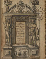
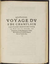
CHAMPLAIN, Samuel de (1567-1635). Les Voyages du Sieur de Champlain Xaintongeois, Capitaine ordinaire pour le Roy, en la marine. Divisez en deux livres. Ou, Journal tres-fidele des observations faites és descouvertures de la Nouvelle France. Paris: Jean Berjon, 1613.
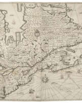
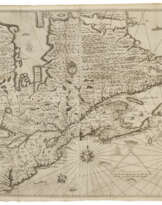
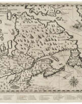
First edition of the first account of all four of Champlain’s voyages to America undertaken between 1604 and 1613. A tall, fresh copy complete with the very rare largest map: “the first to indicate a chain of Great Lakes, Lake Champlain, and Montreal.”
Samuel de Champlain, known as the “Father or New France”, was an extraordinary explorer and leader. He founded the colony of Quebec, charted the Atlantic coast from Newfoundland to Cape Cod, and canoed inland as far as Lake Huron. He established peaceful relations with the Algonquin and Huron and over the course of 30 years nurtured the small French settlements he founded. He was an acute observer, honest chronicler, and an accomplished artist. This is his first illustrated book and in addition to the maps includes depictions of Native people. “Besides John White’s depictions of Carolina Indians later published by de Bry, these are virtually the only images of coastal Indians from the early exploration period which seem to have a basis in actual observation, not seriously tampered with by the engravers” (Creating America).
The work was part of the overall plan to gain as much support as possible for the fledgling colony. It is interesting to note that Champlain relies on only his own first-hand knowledge and what he learns from Natives for his geography. Other European sources that he had not substantiated he relayed with caution. Particularly noticeable are the northern shore of the Gulf of St. Lawrence and the Maritimes marked with the legend “L'auteur na point encore recognu sette coste.” Montreal is shown just a year after Champlain set up a trading post there. However, it was not to be permanently occupied until 1642. The area further upriver is derived from Native sources. Lake Ontario, depicted quite accurately, is marked “Lac Contenant 15 Iourees des canaux des sauuages.” At the western end of the lake is Sault de Au, the first reference on a printed map to Niagara Falls (Burden). The smaller map is nearly as scarce, and important. This map records the discovery by Henry Hudson of the bay named after him. This map has both latitude and longitude, “something virtually never attempted before on a North American map of such detail. Champlain's acute awareness of the deviation of the compass enables him to portray the St. Lawrence River in its more correct south-west to north-east flow rather than the more usual west to east.'' This work also contains the first soundings of North America (Burden).
Champlain’s battle with the Iroquois near present-day Ticonderoga is depicted in the engraving opposite p. 132. In the center is a small figure firing his rifle, a self-portrait of Champlain and the only known lifetime portrait of him. It is also the first published depiction of any scene in present-day New York.
Very rare. According to the auction records of RBH, only two complete copies have sold at auction in the last fifty years: the Siebert-McKinney copy most recently in 2009 and the DuPont copy in 1991. The DuPont copy has the important Hudson Bay map in its second state; the state was not specified in the Siebert copy. In the present copy it is in the extremely rare first state. Alden & Landis 613⁄30; Burden 160-161; Church 360; Harrisse, Nouvelle France 27; Kershaw, 60ff; Lande 116; Sabin 11835; Schwartz & Ehrenberg, pp 85ff; Streeter sale 3630.
Two parts in one, quarto (230 x 183 mm). Eight folding maps including the large “Carte geographique de la nouvelle franse faictte par le sieur de Champlain” (resized, neat reinforcements at folds, a short fold split) and "Carte geographique de la nouvelle franse en son vray mondia" in its first state with a ship in upper right and no indication of the Ottawa River; three additional folding engraved plates; 13 engravings in the text, one woodcut diagram, woodcut head- and tail-pieces and initials (minor browning, small marginal repairs to G4 and I4, K gathering with a pale corner dampstain, blank corners torn from L4, O3, and plate at p.132). Early vellum over boards, spine lettered in Italian manuscript (a few tiny restorations at edges and endpapers). Custom full morocco case. Provenance: a few early unidentified shelf marks – Ernest Keet III (bookplate).
| Artiste: | Samuel de Champlain (1567 - 1635) |
|---|---|
| Lieu d'origine: | Europe de l'Ouest, France, Europe |
| Catégorie maison de vente aux enchères: | Livres imprimés |
| Artiste: | Samuel de Champlain (1567 - 1635) |
|---|---|
| Lieu d'origine: | Europe de l'Ouest, France, Europe |
| Catégorie maison de vente aux enchères: | Livres imprimés |
| Adresse de l'enchère |
CHRISTIE'S 20 Rockefeller Plaza 10020 New York Etats-Unis | ||||||||||||||
|---|---|---|---|---|---|---|---|---|---|---|---|---|---|---|---|
| Aperçu |
| ||||||||||||||
| Téléphone | +1 212 636 2000 | ||||||||||||||
| Fax | +1 212 636 4930 | ||||||||||||||
| Conditions d'utilisation | Conditions d'utilisation | ||||||||||||||
| transport |
Service postal Service de messagerie ramassage par vous-même | ||||||||||||||
| Modes de paiement |
Virement bancaire | ||||||||||||||
| Heures d'ouverture | Heures d'ouverture
|
Termes connexes
Déposer un ordre
Déposer un ordre par téléphone Ordre

| Numéro de lot | 4 |
|---|---|
| Maison de vente aux enchères | CHRISTIE'S |
| Date de l'enchère | 17.01.2024 |
Votre ordre: $ 300 000
Téléphones pour la communication:
+34827387, +232346832
C'est votre offre maximale qui est transmise à la maison des ventes aux enchères. Si l'offre maximale est plus en haut que le prix limite de l'article, le commissaire-priseur offrira pour vous jusqu'à la hauteur de l'offre maximale.
C'est votre enchère maximale, qui est transmise à la maison de vente aux enchères. Si l'enchère maximale est plus haut que le prix minimal de l'article, le commissaire-priseur offrira pour vous jusqu'à la hauteur de l'enchère maximale.
| Numéro de lot | 4 |
|---|---|
| Maison de vente aux enchères | CHRISTIE'S |
| Date de l'enchère | 17.01.2024 |
Erreur ordre
| Numéro de lot | 4 |
|---|---|
| Maison de vente aux enchères | CHRISTIE'S |
| Date de l'enchère | 17.01.2024 |
Вы уже сделали ставку в € 40 000 и ставка принята аукционным домом. Если вы хотите ее уменьшить, то обратитесь напрямую в администрацию аукционного дома.
Erreur ordre
| Numéro de lot | 4 |
|---|---|
| Maison de vente aux enchères | CHRISTIE'S |
| Date de l'enchère | 17.01.2024 |
Вы не можете делать ставки в данном АД, т.к. были внесены в черный список.
Déposer un ordre
| Numéro de lot | 4 |
|---|---|
| Maison de vente aux enchères | CHRISTIE'S |
| Date de l'enchère | 17.01.2024 |
Autobid est prêt
| Numéro de lot | 4 |
|---|---|
| Maison de vente aux enchères | CHRISTIE'S |
| Date de l'enchère | 17.01.2024 |
