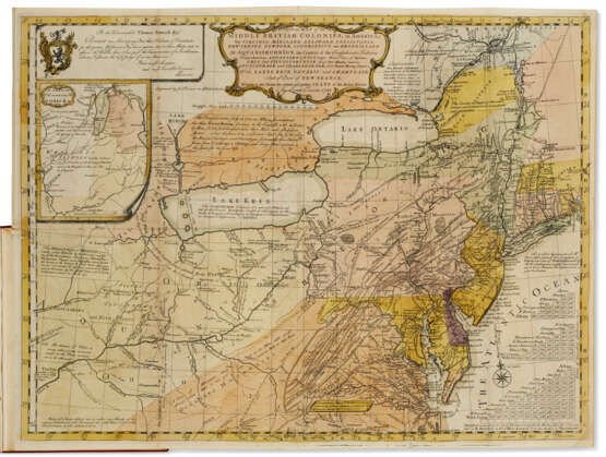
A General Map of the Middle British Colonies

Лот 30
25.05.2022 17:00UTC -05:00
Classic
Продан
$ 138 600
AuctioneerCHRISTIE'S
Место проведенияСША, New York
Архив
Аукцион завершен. Ставки на лот больше не принимаются.
Archive
ID 752758
Лот 30 | A General Map of the Middle British Colonies
Оценочная стоимость
$ 100 000 – 150 000
A General Map of the Middle British ColoniesLewis Evans, 1755EVANS, Lewis (c.1700-1756). Geographical, Historical, Political, Philosophical and Mechanical Essays. The First, Containing an Analysis of a General Map of the Middle British Colonies in America; And of the Country of the Confederate Indians: A Description of the Face of the Country; the Boundaries of the Confederates; and the Maritime and Inland Navigations of the several Rivers and Lakes contained therein. Philadelphia: printed by Benjamin Franklin and D. Hall and sold by R. and J. Dodsley, 1755."One of the most important maps of the British colonies produced prior to Independence, a landmark in American cartography, and an important Franklin printing" (Struggle for North America). This is the first state of the map, hand-colored, without "The Lakes Cataraqui" printed above Lake Ontario. The Analysis, in which Evans carefully acknowledges his sources, is the first edition, London issue, sold by Dodsley but printed by Benjamin Franklin and David Hall.Evans's map was a masterpiece of cartographic synthesis, incorporating information from his own observation with that from the best available sources. His intense study of sources was distilled into this ambitious performance, which builds upon the work which had resulted in his Map of Pennsylvania, New-Jersey, New-York, and the three Delaware Counties of 1754. For Virginia, Evans consulted an early state of Fry and Jefferson's Map of the most inhabited part of Virginia and William Mayo's Map of the Northern Neck of Virginia. From the Fry and Jefferson, Evans adjusted the longitudinal position of the Potomac River and added the area claimed by the Ohio Company to Pennsylvania. He also consulted Walter Hoxton's Mapp of the Bay of Chesepeack, with the Rivers, Potomack, Potapasco, North East, and part of Chester for his delineation of Chesapeake Bay. His sources for Connecticut were the maps of William Douglas and Thomas Pownall—to whom Evans dedicates the map in the upper left panel.The map was eagerly anticipated due to rumors that Evans had amassed new information on the Ohio Valley, not available in John Mitchell's map of the same year. Mitchell was Evans's major competitor, and his A Map of the British and French Dominions had appeared five months before the Evans map. The differences in their border delineations exposed both to critical scrutiny, and Evans had the advantage due to the greater accuracy of his data. Mitchell's was also a more general map, and from the start Evans had set his emphasis on the Ohio Valley, the region that was the source of friction between England and France. The borders in the Evans map were based on much better information. But Mitchell had the benefit of official sanction: the Board of Trade and Plantations had sponsored his map. Evans was working without such support, and thus the official response to Evans's map was cautious. Nonetheless, the great detail and research which informed the Evans map assured its place as one of the most significant maps of the age, and those living in the Colonies recognized its accuracy. "The map evidently excited considerable interest in the Colonies, and, according to what Governor Pownall says in 1776, it was for a long time generally accepted as the standard authority for settling boundaries, purchases, etc., on account of the extreme care and accuracy with which it had been prepared" (Henry N. Stevens, Lewis Evans, His Map, p.6). Evans published a second essay a year later, a rejoinder to criticisms of his map, not present here. Church 1003; Evans 7412; Howes E-226 ("b"); Miller 605a; Pritchard & Taliaferro 34; Sabin 23175; Schwartz & Ehrenberg p.165; Struggle for North America 23; Wheat & Brun 298.Quarto (259 x 190mm). 32 pages. The large engraved folding map with original hand-color: "A General Map of the Middle British Colonies," 500 x 670 mm platemark, 510 x 684 mm sheet (some short fold separations with slight associated rubbing, a 4" closed stub tear with old repair on verso). Modern red morocco by Sangorski & Sutcliffe.
Адрес торгов CHRISTIE'S
20 Rockefeller Plaza
10020 New York
США
Предосмотр
25.05.2022 – 25.05.2022
Телефон +1 212 636 2000
Факс +1 212 636 4930
E-mail
Условия использованияУсловия использования
Транспортировка Почтовая служба
Курьерская служба
Самовывоз
Способы оплаты Банковский перевод
Часы работыЧасы работы
Пн 09:30 – 17:00   
Вт 09:30 – 17:00   
Ср 09:30 – 17:00   
Чт 09:30 – 17:00   
Пт 09:30 – 17:00   
Сб закрыто
Вс закрыто
?>
× Создайте поисковую подписку