ID 1119248
Лот 103 | Battle of Lexington and Concord
Оценочная стоимость
$ 120 000 – 180 000
Isaac de Costa, 1775
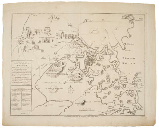
DE COSTA, I[saac] (1728-?). A Plan of the Town and Harbour of Boston and the Country adjacent with the Road from Boston to Concord Shewing the place of the late Engagement between the King's Troops & the Provincials, together with the several Encampments of both Armies in & about Boston. Taken from an Actual Survey...by...J. De Costa. London: published by J. Hand, 6 December 1775.
The first battle plan of the American Revolution.
After a winter of escalating tension between the British government forces and the patriot militia, General Gage, the British commander-in-chief and military commander of Boston, received orders to take vigorous action. On 14 April 1775 he dispatched troops to Concord, the seat of the revolutionary Massachusetts Provincial Congress, to seize military stores that the British spy network had reported. In spite of Gage's strenuous efforts to keep his plan secret, patriot patrols were alerted by the odd movements of British vessels and troops. Thus while 700 British grenadiers and infantrymen were advancing on Concord during the night of April 18, Paul Revere and other couriers were spreading the alarm throughout the local townships. The skirmishes at dawn in Lexington and later in the morning at Concord, and the running battles that followed, are generally estimated to have involved about 3,800 American militia, and to have resulted in the deaths of 49 Americans and 269 British soldiers. Although the precise circumstances of the initial engagements have been endlessly disputed, it is a fact that the events constituted "the transition from intellectual to armed rebellion" (G. F. Scheer and H. F. Rankin, Rebels and Redcoats, 1957, p. 40).
The map shows the Boston area with the harbor and the coast north to Marblehead and south to Weymouth, extending inland to just west of the Concord River. Chronologically it covers the period from April 19th to the date of its original publication on 29 July. The present copy is Pritchard & Taliaferro's state 4, dated 6 December. The deployment of the troops during the battle of Lexington and Concord are depicted with captions, as are the principal encampments of the patriot forces under Washington and Ward and the British army under Putnam following the Battle of Bunker Hill. Other locations or objects are number-keyed to 19 "references" in the title cartouche. Single soldiers, labeled "Minutemen" are shown approaching along the roads from Salem and Woburn. Lexington is shown after the battle: the only human figures are three prone wounded soldiers. The actual action depicted is the battle at Concord, where three groups of provincials are shown firing from behind stone walls or rocks at two British companies (there were actually three). North Bridge is labeled "the Bridge where the attack began." Two wounded soldiers lie on the ground, their headgear denoting them as British, while a group of broken pillar-like objects are identified in the reference key as "Stores & Cannon destroyed by the Kings Troops." To the east two groups of marching troops are labeled "Col. Smith's return from Concord" and "Lord Percy's return from Lexington," but there is no indication of the harassing militia who sniped at the British troops during the entire course of their 16-mile return to Boston.
Rare. According to RBH, only one other copy has appeared at auction since the Streeter sale. Recent research by Michael Buehler has identified the author as Isaac de Costa (or DeCoster), a fourth generation American born in Boston in 1728, who later emigrated to London, then Amsterdam. Cumming, British Maps of Colonial America, pp. 65-66; Nebenzahl, American Revolution, no. 1; Pritchard & Taliaferro, no. 51; Schwartz & Ehrenberg, p.188; Streeter sale 765 (first state).
Engraved map, platemark: 381 x 492mm, sheet size 447 x 545mm. Fourth state, with imprint of J. Hand and engraved by C. Hall. (A couple of marginal tears, some marginal soiling, two small brown spots.)
| Автор: | Исаак де Коста (1728 - ?) |
|---|---|
| Место происхождения: | Англия, Северная Европа, Европа, Великобритания |
| Категория аукционного дома: | Карты и атласы |
| Автор: | Исаак де Коста (1728 - ?) |
|---|---|
| Место происхождения: | Англия, Северная Европа, Европа, Великобритания |
| Категория аукционного дома: | Карты и атласы |
| Адрес торгов |
CHRISTIE'S 20 Rockefeller Plaza 10020 New York США | ||||||||||||||
|---|---|---|---|---|---|---|---|---|---|---|---|---|---|---|---|
| Предосмотр |
| ||||||||||||||
| Телефон | +1 212 636 2000 | ||||||||||||||
| Факс | +1 212 636 4930 | ||||||||||||||
| Условия использования | Условия использования | ||||||||||||||
| Транспортировка |
Почтовая служба Курьерская служба Самовывоз | ||||||||||||||
| Способы оплаты |
Банковский перевод | ||||||||||||||
| Часы работы | Часы работы
|


