![[FOSTER, George (fl. 1735-1740)] – Robert SAYER (1735-1794). - фото 1](https://veryimportantlot.com/assets/image/picture_4084812/704c4/rh5-akqejyjmaug43ncvjup-kaf74qit0wesbihrffucjgdpjhfhqhahybonknkw1719908507jpg__fix_1280_828_fit.jpeg "[FOSTER, George (fl. 1735-1740)] – Robert SAYER (1735-1794). - фото 1")

ID 1249826
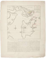
Лот 116 | [FOSTER, George (fl. 1735-1740)] – Robert SAYER (1735-1794).
Оценочная стоимость
£ 10 000 – 15 000
A New & Correct Map of all America, with the West India Islands, according to the definitive treaty concluded at Paris, 10th Feby. 1763. London: printed for Robert Sayer opposite Fetter Lane Fleet Street, [n.d., but probably 1763-1767].
Exceptionally rare map of the Americas, complete with its engraved side-panels, with only two located in institutions, and only one partial copy selling at auction in the past 50 years. It contains the latest important geopolitical updates: the colony of Georgia, established in 1733, is marked, as are other boundary changes in the light of the French and Indian War (1754-1763), including the provinces of Quebec, and East and West Florida. These were all established in 1763 by the provisions of the Treaty of Paris, as indicated by the title.
First published in 1735 by the little-known cartographer George Foster, the geography of this map is clearly derived from Herman Moll’s Map of North America (c.1719), with its directly lifted depictions of the Pacific Northwest and California as an island, and the reworked inset engraving of the Newfoundland fisheries. Foster’s version first appeared as a separate map, and then without side panels in William Keith's rare History of the British Plantations in America (London, 1738; McLaughlin 215 state 3). The present lot is in the sixth state, with the Mississippi delta shifted slightly eastward, and the western boundaries of Virginia, North and South Carolina and Georgia extending to the Mississippi.
The publishing history of maps in London in the 18th century is convoluted, and George Foster’s position within it is not clear. Various business decisions, such as the acquisition of Moll’s copperplates by the Bowles brothers in 1732, and the takeover of Philip Overton’s workshop by Robert Sayer, to say nothing of the availability and reuse of engravings in decorative side panels, have sown confusion.
McLaughlin states that Foster’s map served as the basis for John Bowles and Son’s A New and Exact Map of America of 1754 (Tooley 99 and pl. XL), and is therefore an antecedent of the present lot. But although both share many similarities, the former shows a more distinct influence of Moll with its Beaver vignette, while the present lot omits this. The Bowles map of 1754 is flanked by narrow side-panels of 6 small vignettes derived from John White's account of Virginia, and contemporary accounts of Mexico and Peru published by Theodore De Bry, whereas the present lot has two flanking panels comprising of one large and 8 small vignettes from the same sources. Where the images match, those in the present lot have been re-engraved in reverse to the 1754 Bowles map.
In the present map, the imprint of Foster to bottom right of North Pole inset has been erased, although still faintly visible. Robert Sayer’s imprint appears below the left-hand side panel. This gives the address of ‘opposite Fetter Lane Fleet Street,’ which was Philip Overton’s premises at the Golden Buck. In 1748 Overton’s business was bought by Robert Sayer, who only moved to 53 Fleet Street in 1767, so we deduce this map was produced sometime between 1763 and 1767 (Worms & Baynton-Williams, British Map Engravers, p. 587).
We have only been able to trace one auction record of a map that matches the present lot, and that was the central portion only without side panels (Roland Auctions, Glen Cove, NY, 12 September 2020, lot 378). The British Library only acquired a copy of this map in 1987 (Maps CC.5.a.262; Campbell The Map Collector, 46 (1989): 2-10); the only other institutional copy we can trace is that in the American Philosophical Society, Philadelphia. Later variants of this map are also extremely rare: Boston Rare Maps once had in stock a 1767 issue with a Sayer imprint; and Stanford hold a much later Laurie and Whittle imprint of 1797 with the cartouche completely redone, California as a peninsula, the words United States engraved over the Eastern part of North America, and adds Molls’ famous Beaver image.
References: McLaughlin The mapping of California as an island : an illustrated checklist (1995) 215, state 6, and 240; Tooley California as an island (1964), 99, pl. XL.
Engraved map of North and South America, extending eastwards to show Iceland, the British Isles and the extreme western seaboards of Europe and Africa including the Azores and Cape Verde islands, California shown as an island, with title cartouche over north-west America, 3 small inset maps of the harbours of Port Royal and Boston and the coast of Georgia, inset circular projection of the North Pole to bottom left and vignette of the Newfoundland cod fisheries to bottom right, partial outline colouring by a contemporary hand, bordered by two side panels, each consisting of 9 engraved vignettes showing the customs of indigenous Americans, erased imprint of George Foster and Sons to bottom right of North Pole inset, printed on 3 joined sheets, 555 x 940mm (plate mark), 580 x 975mm (sheet). Provenance: ‘Vol. 59 No 17’ stamped in ink with final number added in ink manuscript on verso at top-centre, probably near-contemporary to date of publication, indicating the map was most probably sometime extracted from a multi-volume atlas.
| Автор: | Джорж Фостер (1704 - ?) Роберт Сейер (1725 - 1794) |
|---|---|
| Место происхождения: | Северная Европа, Европа, Великобритания |
| Категория аукционного дома: | Карты и атласы, Книги и рукописи |
| Автор: | Джорж Фостер (1704 - ?) Роберт Сейер (1725 - 1794) |
|---|---|
| Место происхождения: | Северная Европа, Европа, Великобритания |
| Категория аукционного дома: | Карты и атласы, Книги и рукописи |
| Адрес торгов |
CHRISTIE'S 8 King Street, St. James's SW1Y 6QT London Великобритания | |
|---|---|---|
| Предосмотр |
| |
| Телефон | +44 (0)20 7839 9060 | |
| Комиссия | see on Website | |
| Условия использования | Условия использования |
![[FOSTER, George (fl. 1735-1740)] – Robert SAYER (1735-1794).](/assets/image/picture_4361590/1a26e/13dca103bbf8f022f3e8439e6036e3811733871600jpg__fix_162_205.jpeg)
Связанные термины
Сделать ставку
Ставка по телефону Ставка
![[FOSTER, George (fl. 1735-1740)] – Robert SAYER (1735-1794). - фото 1](/cache/lot/1249826/rh5-AkqejyJMAug43nCVjUp-kaF74qIt0weSBiHRFfucjGdpjHfhqHahYboNkNkW_1719908507-80x80_center_50.jpg "[FOSTER, George (fl. 1735-1740)] – Robert SAYER (1735-1794). - фото 1")
| № лота | 116 |
|---|---|
| Аукционный дом | CHRISTIE'S |
| Дата аукциона | 10.07.2024 |
Ваша ставка: £ 10 000
Телефоны для связи:
+34827387, +232346832
Это Ваша максимальная ставка, которая будет отослана в аукционный дом. Если максимальная ставка больше чем лимит цены на лот, аукционист будет делать ставки за Вас пока максимальная сумма, заданная Вами, не будет исчерпана.
Это Ваша максимальная ставка, которая будет отослана в аукционный дом. Если максимальная ставка больше чем минимальная цена на лот, аукционист будет делать ставки за Вас пока максимальная сумма, заданная Вами, не будет исчерпана.
| № лота | 116 |
|---|---|
| Аукционный дом | CHRISTIE'S |
| Дата аукциона | 10.07.2024 |
Ошибка завершения ставки
| № лота | 116 |
|---|---|
| Аукционный дом | CHRISTIE'S |
| Дата аукциона | 10.07.2024 |
Вы уже сделали ставку в € 40 000 и ставка принята аукционным домом. Если вы хотите ее уменьшить, то обратитесь напрямую в администрацию аукционного дома.
Ошибка завершения ставки
| № лота | 116 |
|---|---|
| Аукционный дом | CHRISTIE'S |
| Дата аукциона | 10.07.2024 |
Вы не можете делать ставки в данном АД, т.к. были внесены в черный список.
Сделать ставку
| № лота | 116 |
|---|---|
| Аукционный дом | CHRISTIE'S |
| Дата аукциона | 10.07.2024 |
Автобид подготовлен
| № лота | 116 |
|---|---|
| Аукционный дом | CHRISTIE'S |
| Дата аукциона | 10.07.2024 |
