ID 794596
Лот 206 | LAURIE, Richard Holmes (1777-1858) and Alexander George FINDLAY (1812-1875)
Оценочная стоимость
£ 3 000 – 5 000
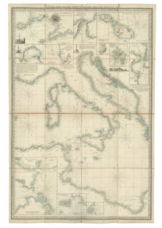
General Chart of the Mediterranean Sea, and a portion of the Euxine or Black Sea … reduced from the original surveys [and] engraved by Alexander Findlay. London: R.H. Laurie, 1840.
Extremely rare, large and decorative general chart of the Mediterranean Sea, from the western seaboard of Portugal and Spain, to its eastern-most point at the Gulf of Iskenderum. The chart has a great level of detail, including 38 finely engraved cartographic insets, coastal profiles and prominent landmarks, including: Carthagena (Spain), Barcelona, Malaga, Bay of Gibraltar, The Strait of Gibraltar by from the survey of Don Jose Lugando, Environs of Marseille, Messina (Italy), Bay of Naples, The Maltese Islands, Valetta, Alexandria (Egypt), The Dardanelles and The Bosphorus.
The chart is based on Admiral William Henry Smyth's Mediterranean surveys carried out between 1810-1824. His highly accurate charts served as the hydrography of record for the Royal Navy during this period as Britain consolidated its military and political influence within the Mediterranean Sea. Further surveys of the Turkish coast by Admiral Sir Francis Beaufort, and the use of charts drawn up by the French Dépôt de la Marine and other continental cartographic sources complemented Smyth’s work, and these are acknowledged in the general title of the present map. R.H. Laurie started to publish the first versions of this map in about 1826, continually expanding the geographical reach and updating its accuracy to produce the present map in 1839. The present lot is actually the ‘improved’ version of the following year, and demonstrates Laurie and Findlay’s commitment to updating their maps as quickly as possible to increase their accuracy. There are manuscript ships’ tracks dated 1840 on the present map indicating that it was pressed quickly into contemporary use. Surprisingly rare, we have only been able to track 2 institutional copies, both held in the British Library; no complete copies can be traced at auction (ABPC/RBH).
Very large folding engraved sea chart, in 3 sections titled ‘The Coasts of France, Spain, Portugal, &c.’, ‘Central part of the Mediterranean, and the Adriatic Sea’, ‘Levantine or Eastern Portion to Syria, Inclusive’, all backed onto the original publisher’s linen with outer panels of green coarse-diapered cloth with printed section labels, each of the charts with engraved borders and latitude and longitude scales, insets of harbours, straits, bays and other hydrographic features, as well as some coastal profiles and prominent landmarks, general title engraved on the eastern chart, imprints with dates of 14 August 1839 at foot of each sheet, but with addition to general title of ‘Improved 1840’, sea coast outlined in blue (each chart 1007 x 677mm; the whole 1007 x 2031mm), the 3 charts contained within the original publisher’s green coarse-diapered cloth slipcase with publisher’s printed paper label, this latter dated August 1839 (259 x 180 x 26mm). Provenance: several manuscript ships’ tracks in black, red and brown ink, with dates of 31 July 1840, 20 December 1840, 2 April 1860, 14 July 1860 and 2 October 1860.
Special notice
No VAT on hammer price or buyer's premium.
| Место происхождения: | Северная Европа, Европа, Великобритания |
|---|---|
| Категория аукционного дома: | Карты и атласы |
| Место происхождения: | Северная Европа, Европа, Великобритания |
|---|---|
| Категория аукционного дома: | Карты и атласы |
| Адрес торгов |
CHRISTIE'S 8 King Street, St. James's SW1Y 6QT London Великобритания | |
|---|---|---|
| Предосмотр |
| |
| Телефон | +44 (0)20 7839 9060 | |
| Комиссия | see on Website | |
| Условия использования | Условия использования |


