


ID 1129828
Лот 208 | Plan of the City of New York
Оценочная стоимость
$ 30 000 – 50 000
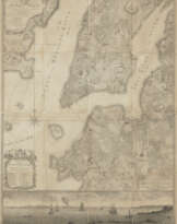
The top sheet of the famous Ratzer Map, used to facilitate the resolution of a real estate dispute over Kips Bay in 1810. A fascinating survival, attesting to the overall accuracy and continued usefulness of Bernard Ratzer's map of New York City as it appeared in the mid 1760s. Using the top sheet only, Anthony Bleecker, New York's Examiner in Chancery, uses the highly-accurate plan to mark the extent of several properties in modern-day Murray Hill and Kips Bay in an effort to adjudicate a land dispute. At the top right corner, several areas have been colored with a key added below noting the locations of "Rose Hill," "Kipp's Bay," and "Bridgen's." A small tract, delineated in orange beside the Eastern Post Road or "Road to Kings Bridge," is identified in the key as "Lotts offered to Tibes," and another small section marked in light blue, located fronting the East River and carved out of "Kipps Farm," is a "Lot sold Coster." On the verso, Anthony Bleecker certifies that "Interrogatories were filed in my office on the part of the Defendants in this Suit … to be examined on the part of the complainants and that within it the original… referred to in the Said Interrogatories and deposed unto by Francis B. Winthrop, James A. Stewart, John R. Murray, Elbert Kip, Henry Brevoort, Henry Cruger, Theodorus Bailey[,] Silvanus Miller and David Hosack…." At present, the resolution of the case remains unknown, but as the case was being considered by the Court of Chancery, Cornelius Kip took out an advertisement offering "Houses & Land, at Kip's Bay, for Sale" located on the "corner of the Main Road and Louisa-street, opposite the pond…." The offering also included "a handsome lot situated on the East River, near the seat of Mr. Henry A. Coster, one hundred feet on the East River…" among other properties and structures. (New-York Evening Post, 12 July 1810, p. 3) A fascinating piece chronicling the development of Kips Bay, worthy of further research.
Partial engraved map on one sheet only (of three), 620 x 900 mm, several sections colored with ink notations below, backed with linen with paper docket affixed to verso (mild dampstains, a few partial fold separations, some soiling to linen backing) Framed to reveal both recto and verso. Not examined out of frame.
| Автор: | Бернард Ратцер (1700 - ?) |
|---|---|
| Место происхождения: | США |
| Категория аукционного дома: | Карты и атласы |
| Автор: | Бернард Ратцер (1700 - ?) |
|---|---|
| Место происхождения: | США |
| Категория аукционного дома: | Карты и атласы |
| Адрес торгов |
CHRISTIE'S 20 Rockefeller Plaza 10020 New York США | ||||||||||||||
|---|---|---|---|---|---|---|---|---|---|---|---|---|---|---|---|
| Предосмотр |
| ||||||||||||||
| Телефон | +1 212 636 2000 | ||||||||||||||
| Факс | +1 212 636 4930 | ||||||||||||||
| Условия использования | Условия использования | ||||||||||||||
| Транспортировка |
Почтовая служба Курьерская служба Самовывоз | ||||||||||||||
| Способы оплаты |
Банковский перевод | ||||||||||||||
| Часы работы | Часы работы
|
Связанные термины
Сделать ставку
Ставка по телефону Ставка

| № лота | 208 |
|---|---|
| Аукционный дом | CHRISTIE'S |
| Дата аукциона | 02.02.2024 |
Ваша ставка: $ 24 000
Телефоны для связи:
+34827387, +232346832
Это Ваша максимальная ставка, которая будет отослана в аукционный дом. Если максимальная ставка больше чем лимит цены на лот, аукционист будет делать ставки за Вас пока максимальная сумма, заданная Вами, не будет исчерпана.
Это Ваша максимальная ставка, которая будет отослана в аукционный дом. Если максимальная ставка больше чем минимальная цена на лот, аукционист будет делать ставки за Вас пока максимальная сумма, заданная Вами, не будет исчерпана.
| № лота | 208 |
|---|---|
| Аукционный дом | CHRISTIE'S |
| Дата аукциона | 02.02.2024 |
Ошибка завершения ставки
| № лота | 208 |
|---|---|
| Аукционный дом | CHRISTIE'S |
| Дата аукциона | 02.02.2024 |
Вы уже сделали ставку в € 40 000 и ставка принята аукционным домом. Если вы хотите ее уменьшить, то обратитесь напрямую в администрацию аукционного дома.
Ошибка завершения ставки
| № лота | 208 |
|---|---|
| Аукционный дом | CHRISTIE'S |
| Дата аукциона | 02.02.2024 |
Вы не можете делать ставки в данном АД, т.к. были внесены в черный список.
Сделать ставку
| № лота | 208 |
|---|---|
| Аукционный дом | CHRISTIE'S |
| Дата аукциона | 02.02.2024 |
Автобид подготовлен
| № лота | 208 |
|---|---|
| Аукционный дом | CHRISTIE'S |
| Дата аукциона | 02.02.2024 |
