ID 381304
Лот 96 | Ferdinand Verbiest (1623-1688)
Оценочная стоимость
£ 10 000 – 15 000
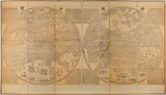
One of the largest world maps ever printed. Verbiest's original is as rare as its forerunner produced by Matteo Ricci at Beijing in 1602 (or its now-lost predecessors). This reprint is almost as rare. It is easily distinguished from the 1674 by the addition of a new imprint in Chinese (accompanied with a chop in this example), and by the fact that the text in the spandrels of the original is within differently-shaped frames. The map itself has many similarities to Ricci's (on a Mercator projection), with updating to reflect European (largely English) exploration of the Canadian Arctic and Greenland.
A remarkable piece of printing by the Jesuits in China, published to mark their official return to favour. Beginning with Ricci at the end of the sixteenth century, the Jesuits were really only tolerated in China as scientific advisers and were not allowed to embark on a general mission throughout the country, nevertheless the influence at the imperial court of Ricci's successor, Adam Schall von Bell aroused the jealousy of imperial agents who, on the pretext of the Jesuits supposedly preparing the way for Portuguese occupation, in 1664 had Schall von Bell and five assistants sentenced to death. Schall von Bell was reprieved, but his Chinese assistants were executed and all the priests in China were rounded up in Canton with a view to being expelled. It wasn't until 1667 when the young Emperor K'ang-Hsi began to take a hand in the affairs of government and made friends with Schall's successor, Ferdinand Verbiest, that the measures taken against the Christians were rescinded and the position of the Fathers made secure.
The 1674 original is reproduced in 'Europa und die Kaiser' (Frankfurt, 1985), at p.109-111. A Canton version c.1860 is reproduced (in error for the original), in 'Chine Ciel et Terre' (Gent, 1982), at p.408-409.
Large xylographic map (1500 x 3000mm), printed on 6 sheets, the southern polar landmass embellished with animals, including a unicorn, a lion, a rhinoceros, a crocodile, a giraffe, a beaver and a turkey, the spandrels with eight large lozenges with text descriptions, mounted on a large screen.
| Адрес торгов |
CHRISTIE'S 8 King Street, St. James's SW1Y 6QT London Великобритания | |
|---|---|---|
| Предосмотр |
| |
| Телефон | +44 (0)20 7839 9060 | |
| Комиссия | see on Website | |
| Условия использования | Условия использования |


