ID 627566
Лот 76 | Great Atlas of the Unified Imperial China
Оценочная стоимость
$ 150 000 – 250 000
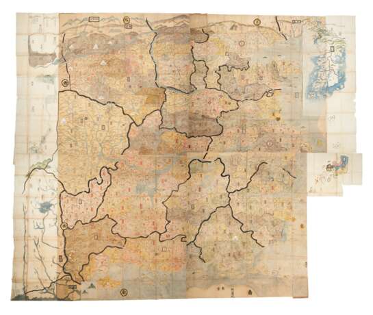
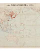
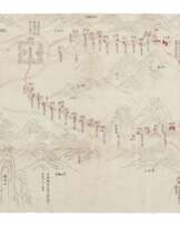
An extremely large and beautiful early Chinese manuscript map of China, expanded about a century later to a world map, via Japanese additions. This map is composed of four sections, each with two layers of painting. The square center of the map was painted first in China on thicker paper, with the several adjoining peripheral maps affixed to the margins of the central map, these painted in Japan, dated to the autumn of the eighth year of Meiwa era (1771). The borders of the central map are as follows: Datong Prefecture in the north, Yazhou Prefecture (established in 1729, inferior to Sichuan Province) in the west; the Guangdong coast to the south and the East China Sea to the east. Fifteen provinces are rendered with affirmative thick ink outlines, striking a strong contrast with the pale colors applied to depict the geographical and sub-provincial features of the map. The numerous color patches in the map represents lands of prefectures with red name labels or with labels that have red borders. The present lot does not reflect the division of Huguang Province into Hubei and Hunan Provinces actualized by Emperor Kangxi in 1663, thus the execution date of the map should be around or slightly later than 1663, considering the possibility of information delay. The Annam Kingdom, Korea and Ryukyu Kingdom are depicted around the margins of the map. Europe, however, is mistakenly placed to the south of China, facing Guangdong coast and is annotated Nanman (Southern Barbarian) and Alantuo (Netherlands). The maps peripheral to the central square were added in 1771 in Japan, and extend the map to show those territories recently incorporated under China’s dominion, including Xinjiang, Inner Mongolian and Tibet, as well as other neighboring countries including Uzbekistan, India, Laos, Korea and Japan. In the lower left corner of the lower left peripheral sheet, inscriptions by the second cartographer state that the central square map was in the collection of Ono Chikuzen Mamuro, who may be the father or someone related to the poet and calligrapher Ono Shigekata (1776-1834), also known as Ono Chikuzen Mamuro and Ban Shigekata. References: Reading Imperial Cartography: Ming-Qing historical maps in the Library of Congress (2013), pp. 88-89; Richard Pegg, Cartographic Traditions in East Asian Maps (2014) pp.8-9, 18-26; Richard Smith, Chinese Maps: Images of ‘All Under Heaven’ (1996).
Large manuscript world map of China, ink and color on two types of paper, texts in Chinese, approximately 12 by 17 feet in size overall, composed of four separate folded maps, each map with a front and back paper covers, title slips on the front covers, and several sheets of paper, approximately 1880 x 2180 mm each (over six by seven feet), and 275 x 230 mm each folded, housed together in a 490 x 330 mm blue cloth case. The central map is painted on thicker brownish paper and the wide left and right borders are of thin rice paper, painted with Japan, Korea and hills and rivers remote to the administrative divisions of China. The disconnected pigment around some folds shows that the folds existed when the map was painted. Some areas at the back strengthened with patches of paper. A piece of square rice paper drawn with two hills pasted to the south of Guangdong Province. (Areas of fading and discoloration, white pigment used for snowy mountains and steles slightly chipped off, some surface abrasions—especially the area around Yunnan Province in the second map, and in the third map, causing the loss of some characters; holes at folds, wormholes and some marginal tears. Paper covers well worn.) Provenance: Ono Chikuzen Mamuro (18th century inscription, probably the commissioner of the world map components) – China Guardian, 14 November 2016, lot 2132.
Exhibited: “The World on Paper: From Square to Sphericity,” Hong Kong Maritime Museum, December 2019 to March 2020.
Please note that this lot is subject to an import tariff. If the buyer instructs Christie’s to arrange shipping of the lot to a foreign address, the buyer will not be required to pay the import tariff. If the buyer instructs Christie’s to arrange shipping of the lot to a domestic address, if the buyer collects the property in person, or if the buyer arranges their own shipping (whether domestically or internationally), the buyer will be required to pay the import tariff. Please contact Post Sale Services on +1 212 636 2650 prior to bidding for more information.
| Автор: | Уильям Шекспир (1564 - 1616) |
|---|---|
| Техника исполнения: | Карандаш |
| Автор: | Уильям Шекспир (1564 - 1616) |
|---|---|
| Техника исполнения: | Карандаш |
| Адрес торгов |
CHRISTIE'S 8 King Street, St. James's SW1Y 6QT London Великобритания | |
|---|---|---|
| Предосмотр |
| |
| Телефон | +44 (0)20 7839 9060 | |
| Комиссия | see on Website | |
| Условия использования | Условия использования |
